1900s (20th Century) Maps of Boise, Idaho
Explore 14 historic maps of Boise from the 1900s (20th Century). These maps offer a rare glimpse into what life looked like during the 1900s — showing old roads, neighborhoods, homes, and landmarks that have changed or disappeared over time.
Whether you're researching your family's past, planning a metal detecting trip, or studying how Boise's landscape evolved across the 1900s, these high-resolution maps are a powerful tool for exploring the history of this region.
- Focus on a specific era: All maps on this page are from the 1900s, giving you a focused view of this time period.
- See what’s changed: Compare century-old streets, trails, and buildings to today's modern landscape using overlays and satellite layers.
- Research with precision: Use these maps for genealogy, historical research, land use analysis, or educational projects.
- View, download, or print: Maps are fully viewable online in high resolution, and can be downloaded or printed for your own records.
Start exploring Boise's history through authentic maps from the 1900s. This is your window into the past.
Boise, ID maps
(14)- 1953 Map of Eagle, 1955 Print
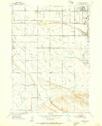
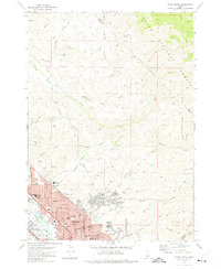
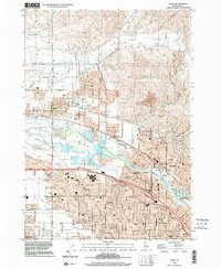
 1953 Eagle1955 Print · USGSThe Boise River valley in the early fifties shows a landscape of irrigation canals and early aviation. Genealogists can locate McMillan Chapel, Dry Creek Cem, and several schoolhouses like Green Meadows Sch.5 unique versions available
 - 1953 Map of Cloverdale, 1955 Print
 1953 Cloverdale1955 Print · USGSAda County in the early fifties is shown here as a productive landscape of family farms and irrigation canals. Genealogists can trace rural life through numerous district schools like Hillsdale Sch and landmarks like the Tenmile Rodeo Grounds or Cloverdale Memorial Park.4 unique versions available
 - 1954 Map of Boise South, 1956 Print
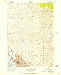
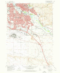
 1954 Boise South1956 Print · USGSMid-century Boise shows a rapidly growing capital city and its vital irrigation network just before the height of the suburban boom. Genealogists and historians can trace Pioneer Cemetery, the State Penitentiary, and the original campus of Boise Jr College.2 unique versions available
 - 1954 Map of Boise North, 1957 Print
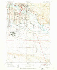
 1954 Boise North1957 Print · USGSBoise and Garden City are captured in the mid-fifties as the city began to climb the foothills and expand along the river. Genealogists and local historians can locate early institutions like the Soldiers Home, Collister Sch, and the Boise City Canal.2 unique versions available
 - 1954 Map of Boise, 1958 Print
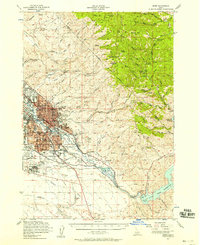 1954 Boise1958 Print · USGSBoise and the surrounding Idaho foothills are captured here in the mid-fifties, just as suburban expansion began meeting the rugged edge of the Boise National Forest. Researchers can trace the Old Oregon Trail, locate the State Penitentiary, and find long-established schools like St Marys Sch.2 unique versions available
 - 1955 Map of Boise, 1977 Print
 1955 Boise1977 Print · USGSThe Treasure Valley and Owyhee uplands are shown in detail during the mid-fifties, capturing the region's transition into a major agricultural and urban hub. Researchers can trace the Union Pacific line through Nampa, explore the volcanic Jordan Craters, or locate the historic mining district of Silver City.
 - 1958 Map of Boise
 1958 Boise1958 Print · USGSThe Treasure Valley and Snake River Plain come alive in the mid-fifties as the rail-and-river economy transitions into a modern agricultural hub. Trace the Union Pacific lines through Nampa or locate remote landmarks like Initial Point and the Rockville settlement.2 unique versions available
 - 1962 Map of Boise
 1962 Boise1962 Print · USGSThe Treasure Valley at the start of the sixties reveals a landscape of expanding towns and complex irrigation networks along the Snake River. Genealogists and historians can trace the foundations of modern Idaho through markers like Initial Point, the mining history of Silver City, and the early infrastructure of Lucky Peak Dam.
 - 1972 Map of Boise North, 1975 Print
 1972 Boise North1975 Print · USGSBoise and Garden City expand into the Idaho foothills during the early seventies, showing a growing urban grid meeting the national forest. Researchers can trace neighborhood development and local history through landmarks like Lowell Sch, the Old Military Reservation, and Stewart Gulch.3 unique versions available
 - 1972 Map of Lucky Peak, 1975 Print
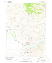 1972 Lucky Peak1975 Print · USGSThe Boise River valley and the slopes of Shaw Mountain were centers of mining and water engineering in the 1970s. Researchers can trace the Oregon Trail, locate old diggings at the Adelmann Mine, and explore the infrastructure of the Lucky Peak Dam.
 - 1972 Map of Boise South, 1976 Print
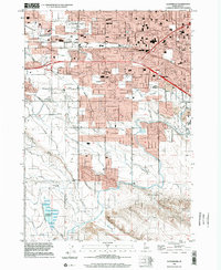
 1972 Boise South1976 Print · USGSBoise and the surrounding Idaho plains are captured during a decade of rapid modernization and civic growth. Researchers can trace the mid-century layout of Boise State College or locate the historic Military Cem and the State Penitentiary.4 unique versions available
 - 1981 Map of Boise
 1981 Boise1981 Print · USGSThe Boise River valley and Treasure Plain are captured here in the early eighties as urban expansion began to link the regional hubs of the Snake River plain. Researchers can trace the development of Nampa, Caldwell, and Meridian or locate landmarks like Lake Lowell and Eagle Island State Park.2 unique versions available
 - 1998 Map of Cloverdale, 2002 Print
 1998 Cloverdale2002 Print · USGSThe Boise and Meridian borderlands come into focus during the late nineties as residential growth meets the valley's irrigation network. Genealogists and historians can locate Cloverdale Mem. Park (Cem) and legacy schools like Cole Sch and Locust Grove Sch.
 - 1998 Map of Eagle, 2002 Print
 1998 Eagle2002 Print · USGSThe Boise River valley is captured here in a period of transition as suburban expansion meets historic agriculture. Genealogists and historians can trace family-named sites like McMillan Chapel, find the Joplin Cem, and locate several abandoned schoolhouses.
End of results
Showing maps 1-14 of 14
Top cities near Boise
- Meridian historical maps
- Eagle historical maps
- Kuna historical maps
- Star historical maps
- Garden City historical maps
- Hidden Springs historical maps
Top neighborhoods of Boise
- Southeast Boise historical maps
- East End historical maps
- North End historical maps
- Boise Junction historical maps
- Highlands historical maps
- Historic South Boise Streetcar Station Plaza historical maps
See more
Frequently asked questions
- What are the different types of historical maps available for Boise?
- What is the oldest map of Boise?
- Where can I purchase historical maps of Boise for my home or office?
- Where can I download high-res historical maps of Boise?
- Are there historical topographic maps available for Boise?
- Is there historical aerial imagery available for Boise?
- Where are historical maps of Boise sourced from?