1900s (20th Century) Maps of Downey, Idaho
Explore 5 historic maps of Downey from the 1900s (20th Century). These maps offer a rare glimpse into what life looked like during the 1900s — showing old roads, neighborhoods, homes, and landmarks that have changed or disappeared over time.
Whether you're researching your family's past, planning a metal detecting trip, or studying how Downey's landscape evolved across the 1900s, these high-resolution maps are a powerful tool for exploring the history of this region.
- Focus on a specific era: All maps on this page are from the 1900s, giving you a focused view of this time period.
- See what’s changed: Compare century-old streets, trails, and buildings to today's modern landscape using overlays and satellite layers.
- Research with precision: Use these maps for genealogy, historical research, land use analysis, or educational projects.
- View, download, or print: Maps are fully viewable online in high resolution, and can be downloaded or printed for your own records.
Start exploring Downey's history through authentic maps from the 1900s. This is your window into the past.
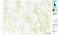
Downey, ID maps
(5)- 1954 Map of Pocatello, 1963 Print
 1954 Pocatello1963 Print · USGSSoutheast Idaho in the mid-1950s reveals a landscape shaped by massive water reclamation and mountain forests. Researchers can trace the development of the Fort Hall Indian Reservation or locate specific landmarks like the Arbon P O and Emerson School.4 unique versions available
 - 1958 Map of Pocatello
 1958 Pocatello1958 Print · USGSSoutheastern Idaho in the late fifties was a landscape of expanding reservoirs and historic trails. Genealogists and historians can trace the Old Oregon Trail, locate the Bannock Creek Indian Day School, and study the many Union Pacific rail sidings.2 unique versions available
 - 1968 Map of Downey West, 1971 Print
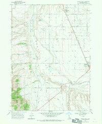 1968 Downey West1971 Print · USGSBannock County's Marsh Valley is seen here in the late sixties as a thriving rail and irrigation corridor. Trace family history at the Woodland Cem or explore the infrastructure around Downey, including the Bannock County Fairgrounds and the Union Pacific line.2 unique versions available
 - 1968 Map of Downey East, 1971 Print
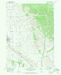 1968 Downey East1971 Print · USGSBannock County was a corridor of rail and road travel in the late sixties, centered on the irrigation and ranching of Marsh Valley. Genealogists and historians can trace the foundations of Downey, locate the Grant Ward Cem, and find the historic Downata Hot Springs.2 unique versions available
 - 1984 Map of Malad City
 1984 Malad City1984 Print · USGSSoutheastern Idaho in the mid-eighties shows a landscape of high valleys and prominent ranges between the Malad and Curlew basins. Genealogists and historians can trace the foundations of local ranching communities like Samaria, Holbrook, and Arbon, or locate the Black Pine Bird Sanctuary.2 unique versions available
End of results
Showing maps 1-5 of 5
Top cities near Downey
- Malad City historical maps
- McCammon historical maps
- Lava Hot Springs historical maps
- Arimo historical maps
- Oxford historical maps
Frequently asked questions
- What are the different types of historical maps available for Downey?
- What is the oldest map of Downey?
- Where can I purchase historical maps of Downey for my home or office?
- Where can I download high-res historical maps of Downey?
- Are there historical topographic maps available for Downey?
- Is there historical aerial imagery available for Downey?
- Where are historical maps of Downey sourced from?