1980s Maps of Boundary County, Idaho
Explore 2 historic maps of Boundary County from the 1980s. These maps offer a rare glimpse into what life looked like during the 1980s — showing old roads, neighborhoods, homes, and landmarks that have changed or disappeared over time.
Whether you're researching your family's past, planning a metal detecting trip, or studying how Boundary County's landscape evolved across the 1980s, these high-resolution maps are a powerful tool for exploring the history of this region.
- Focus on a specific era: All maps on this page are from the 1980s, giving you a focused view of this time period.
- See what’s changed: Compare century-old streets, trails, and buildings to today's modern landscape using overlays and satellite layers.
- Research with precision: Use these maps for genealogy, historical research, land use analysis, or educational projects.
- View, download, or print: Maps are fully viewable online in high resolution, and can be downloaded or printed for your own records.
Start exploring Boundary County's history through authentic maps from the 1980s. This is your window into the past.
Boundary County, ID maps
(2)- 1983 Map of Bonners Ferry
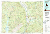 1983 Bonners Ferry1983 Print · USGSThe Idaho Panhandle and its international border with Canada are shown here in the early 1980s as the timber and mining industries shaped the landscape. Genealogists and researchers can locate northern settlements like Porthill and Naples, alongside family-named peaks and mines such as the American Girl Mine and Parker Mtn.2 unique versions available
 - 1984 Map of Colville
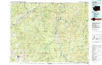 1984 Colville1984 Print · USGSNortheastern Washington and the Idaho borderlands are documented here in the mid-1980s as the regional economy balanced forestry and mineral extraction. Genealogists and researchers can trace dozens of mountain mining operations like Van Stone Mine alongside timber settlements such as Metaline Falls and Aladdin.2 unique versions available
End of results
Showing maps 1-2 of 2
Top cities of Boundary County
Frequently asked questions
- What are the different types of historical maps available for Boundary County?
- What is the oldest map of Boundary County?
- Where can I purchase historical maps of Boundary County for my home or office?
- Where can I download high-res historical maps of Boundary County?
- Are there historical topographic maps available for Boundary County?
- Is there historical aerial imagery available for Boundary County?
- Where are historical maps of Boundary County sourced from?