1950s Maps of Butte County, Idaho
Explore 6 historic maps of Butte County from the 1950s. These maps offer a rare glimpse into what life looked like during the 1950s — showing old roads, neighborhoods, homes, and landmarks that have changed or disappeared over time.
Whether you're researching your family's past, planning a metal detecting trip, or studying how Butte County's landscape evolved across the 1950s, these high-resolution maps are a powerful tool for exploring the history of this region.
- Focus on a specific era: All maps on this page are from the 1950s, giving you a focused view of this time period.
- See what’s changed: Compare century-old streets, trails, and buildings to today's modern landscape using overlays and satellite layers.
- Research with precision: Use these maps for genealogy, historical research, land use analysis, or educational projects.
- View, download, or print: Maps are fully viewable online in high resolution, and can be downloaded or printed for your own records.
Start exploring Butte County's history through authentic maps from the 1950s. This is your window into the past.
Butte County, ID maps
(6)- 1955 Map of Dubois
 1955 Dubois1955 Print · USGSThe high desert and mountain passes of eastern Idaho and western Montana are captured here during the mid-fifties. Researchers can trace the Union Pacific rail line through Dubois or locate the National Reactor Testing Station.4 unique versions available
 - 1955 Map of Idaho Falls, 1963 Print
 1955 Idaho Falls1963 Print · USGSThe Snake River Plain and its surrounding volcanic peaks are captured in the late fifties, showing the region's unique mix of nuclear research and high-desert ranching. Trace the industrial footprint of the National Reactor Testing Station or find old mining sites like Empire Mine.5 unique versions available
 - 1957 Map of Diamond Peak, 1958 Print
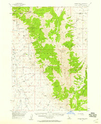 1957 Diamond Peak1958 Print · USGSThe high Lemhi Range of the late fifties reveals a landscape defined by mining prospects and mountain hydrology. Genealogists and historians can trace early activity at Clyde, locate the Badger Mine, or identify family-named landmarks like Foss Mountain.3 unique versions available
 - 1957 Map of Hawley Mountain, 1959 Print
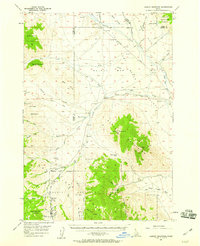 1957 Hawley Mountain1959 Print · USGSHigh mountain peaks and arid valley basins define this Idaho backcountry in the late fifties. Genealogists and historians can trace high-altitude routes like Pass Creek Road through the Challis National Forest and locate seasonal landmarks such as Magpie Springs and Mulkey Bar.2 unique versions available
 - 1958 Map of Dubois
 1958 Dubois1958 Print · USGSThe high divide between Idaho and Montana comes alive in this mid-century survey, from the mining camps of the Lemhi Range to the ranchlands of Centennial Valley. Trace historic operations at the Copper Queen Mine, the route of the Union Pacific RR, and the scientific work at the Sheep experimental station.2 unique versions available
 - 1958 Map of Idaho Falls
 1958 Idaho Falls1958 Print · USGSEastern Idaho in the late fifties showcases the rapid expansion of agricultural and scientific outposts across its volcanic plains. Researchers can locate remote sites like Atomic City, mineral interests at White Knob Mine, and the cultural grounds of St Marys Mission.2 unique versions available
End of results
Showing maps 1-6 of 6
Top cities of Butte County
Frequently asked questions
- What are the different types of historical maps available for Butte County?
- What is the oldest map of Butte County?
- Where can I purchase historical maps of Butte County for my home or office?
- Where can I download high-res historical maps of Butte County?
- Are there historical topographic maps available for Butte County?
- Is there historical aerial imagery available for Butte County?
- Where are historical maps of Butte County sourced from?