1980s Maps of Camas County, Idaho
Explore 16 historic maps of Camas County from the 1980s. These maps offer a rare glimpse into what life looked like during the 1980s — showing old roads, neighborhoods, homes, and landmarks that have changed or disappeared over time.
Whether you're researching your family's past, planning a metal detecting trip, or studying how Camas County's landscape evolved across the 1980s, these high-resolution maps are a powerful tool for exploring the history of this region.
- Focus on a specific era: All maps on this page are from the 1980s, giving you a focused view of this time period.
- See what’s changed: Compare century-old streets, trails, and buildings to today's modern landscape using overlays and satellite layers.
- Research with precision: Use these maps for genealogy, historical research, land use analysis, or educational projects.
- View, download, or print: Maps are fully viewable online in high resolution, and can be downloaded or printed for your own records.
Start exploring Camas County's history through authentic maps from the 1980s. This is your window into the past.
Camas County, ID maps
(16)- 1982 Map of Idaho City
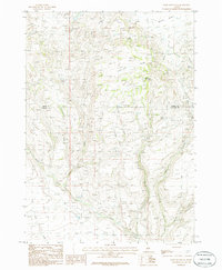
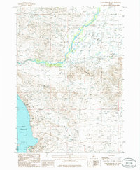
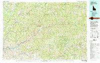 1982 Idaho City1982 Print · USGSThe Boise Basin and surrounding mountains appear in the early 1980s as a land transitioning from its gold-mining roots to a recreation-focused forest landscape. Researchers can trace historic mining operations at the Gold Hill Mine or locate remote settlements like Atlanta, Rocky Bar, and Featherville.
 - 1986 Map of Phillips
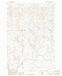
 1986 Phillips1986 Print · USGSThe Idaho high country meets the valley floor in the mid-1980s, revealing the transition from the timbered Soldier Mountains to the level Camas Prairie. Trace early mineral interest near Free Gold Creek or locate the quiet Cem situated along the lower reach of Soldier Creek.2 unique versions available
 - 1986 Map of Thorn Creek Reservoir
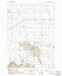
 1986 Thorn Creek Reservoir1986 Print · USGSCamas County and its neighbors meet at this high-desert plateau in the mid-1980s, revealing a landscape defined by water management and range life. Researchers can locate remote water sources like Barrel Water Hole, name-bearing springs such as Eusebio Spring, and the drainage of Rattlesnake Canyon.
 - 1986 Map of Fir Grove Mountain
 1986 Fir Grove Mountain1986 Print · USGSThe high desert and canyonlands of Camas and Gooding Counties are captured in the mid-1980s, centered on the landmark Fir Grove Mountain. Researchers can trace the water sources and early trails surrounding Mormon Reservoir, Hot Spring, and the unique City of Rocks formation.
 - 1986 Map of Corral
 1986 Corral1986 Print · USGSThe Camas Prairie of southern Idaho is shown here in the mid-eighties as a landscape of remote farmsteads and rural outposts. Researchers can trace the Old Railroad Grade and locate family-named landmarks like Brownell Spring, Leahy Spring, and the settlement of Corral.
 - 1986 Map of Cannonball Mountain
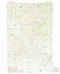
 1986 Cannonball Mountain1986 Print · USGSThe Soldier Mountains and Sawtooth National Forest are captured here in the mid-1980s, just as the Camas Prairie meets the high ridges. Researchers can locate remote industrial sites like the Saumill and various Prospects, or trace the winding path of Camas Creek.
 - 1986 Map of Beaver Creek
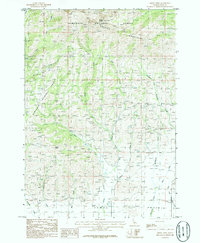
 1986 Beaver Creek1986 Print · USGSThe high peaks of the Soldier Mountains meet the Camas Prairie in the mid-1980s, revealing a landscape of remote resource exploration. Researchers can trace numerous mountain prospect sites and four-wheel-drive trails near Beaver Creek and Square Mountain.
 - 1986 Map of Smoky Dome
 1986 Smoky Dome1986 Print · USGSThe high Soldier Mountains and northern Camas Prairie are captured in the mid-1980s before modern development altered these Idaho highlands. Researchers can trace remote mountain trails and identify local landmarks like Smoky Dome, Sheep Point, and a lone Cem.
 - 1986 Map of Dempsey Meadows
 1986 Dempsey Meadows1986 Print · USGSElmore County’s high country is captured here during the mid-1980s, at the intersection of three Idaho counties. Researchers can trace the rugged drainage patterns of Dempsey Meadows and identify landmarks like The Knob and Clover Creek.
 - 1986 Map of Magic Reservoir West
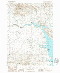 1986 Magic Reservoir West1986 Print · USGSCamas County and Blaine County meet at the edge of the Magic Reservoir in the mid-1980s. Local researchers can trace the footprint of leisure and industry through Moonstone Landing, the Abandoned Railroad, and the remote Magic Resort.
 - 1986 Map of Fairfield
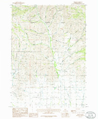
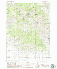
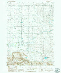
 1986 Fairfield1986 Print · USGSCamas County ranching and water infrastructure are well-documented in the mid-1980s as Fairfield anchors the surrounding plains. Researchers can trace the Abandoned Railroad Grade and locate features like Soldier or the Mormon Reservoir.
 - 1986 Map of Davis Mountain
 1986 Davis Mountain1986 Print · USGSThe high plateau of south-central Idaho is captured here in the mid-1980s as a landscape of remote rangelands and vital water sources. Researchers can trace the network of springs and creeks, including Big Spring, Erma Spring, and the prominent peak of Davis Mountain.
 - 1986 Map of Magic Reservoir East
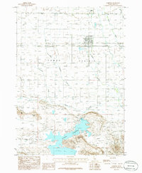
 1986 Magic Reservoir East1986 Print · USGSThe Big Wood River valley and the eastern edge of Magic Reservoir are captured here in the mid-1980s. Local historians and land researchers can trace the roads near Magic City, locate several Prospects, and explore named terrain like Rattlesnake Butte.
 - 1986 Map of Spring Creek Reservoir
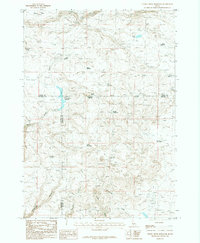
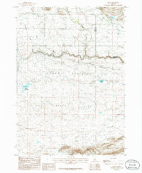
 1986 Spring Creek Reservoir1986 Print · USGSCamas County is documented here during the mid-1980s, showing the agricultural heart of the high prairie and its evolving transportation. Researchers can trace the path of the Abandoned Railroad and locate old siding points and settlements like Rands and Selby.
 - 1986 Map of Mc Han Reservoir
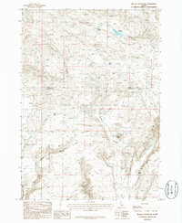 1986 Mc Han Reservoir1986 Print · USGSThe high plateau of Gooding and Camas Counties is captured in the mid-1980s, showcasing a landscape of basalt flows and desert canyons. Researchers can trace historic water sources like Bull Spring and remote landmarks including the Little City of Rocks and Flat Top Butte.
 - 1986 Map of Macon
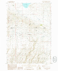
 1986 Macon1986 Print · USGSCamas County is captured during the mid-1980s, showing the agricultural rhythm and changing transportation of the high Idaho plains. Trace the route of the Abandoned Railroad through Macon or locate local landmarks like Kelly Reservoir and Chicken Spring.
End of results
Showing maps 1-16 of 16
Top cities of Camas County
Frequently asked questions
- What are the different types of historical maps available for Camas County?
- What is the oldest map of Camas County?
- Where can I purchase historical maps of Camas County for my home or office?
- Where can I download high-res historical maps of Camas County?
- Are there historical topographic maps available for Camas County?
- Is there historical aerial imagery available for Camas County?
- Where are historical maps of Camas County sourced from?