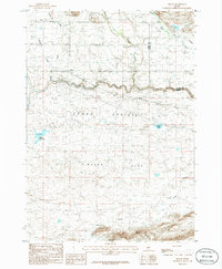
1986 Map of Macon
USGS Topo · Published 1986About this map
Camas Prairie defines the northern reaches of this central Idaho landscape, where the settlements of Macon and Blaine sit along the winding course of Camas Creek. The map documents a transition in transportation and water management during the mid-1980s, most notably featuring a prominent Abandoned Railroad that parallels the creek through the valley floor. This rail line once served the agricultural interests of the Macon Flat region, a broad expanse that stretches south toward volcanic features like Lava Creek. Hydrological patterns are central to the area's character, with numerous drainages such as Willow Creek, Camp Creek, and Minnehaha Creek flowing from the higher elevations to the north. Man-made interventions in this arid environment are evident at Kelly Reservoir and the more localized Macon Lake, illustrating the vital role of water storage for the high-altitude ranching and farming communities of Camas County.
Find a feature on this map
17 named features on this map. Tap any name to fly to it.
Don’t see what you’re looking for? This feature index may not catch every label — zoom into the map to look around manually.
Map Details
Editions of this 1986 Macon Map
This is the sole edition of this map. No revisions or reprints were ever made.
Other maps of this area

1955 · Hailey
USGS Topo · 1:250,000

1957 · Thorn Creek
USGS Topo · 1:62,500

1957 · Bellevue
USGS Topo · 1:62,500

1957 · Blaine
USGS Topo · 1:62,500

1959 · Hailey
USGS Topo · 1:250,000

1962 · Hailey
USGS Topo · 1:250,000

1979 · Summit Reservoir
USGS Topo · 1:24,000
1986 · Thorn Creek Reservoir
USGS Topo · 1:24,000
1986 · Cannonball Mountain
USGS Topo · 1:24,000
1986 · Beaver Creek
USGS Topo · 1:24,000