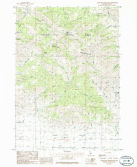
1986 Map of Cannonball Mountain
USGS Topo · Published 1986About this map
Sawtooth National Forest dominates this Idaho landscape, encompassing the steep ridges and drainage basins of the Soldier Mountains. The terrain is defined by a dense network of waterways including Cannonball Creek, Little Deer Creek, and Big Deer Creek, all flowing south toward the agricultural flats of the Camas Prairie. Rising to a prominent peak, Cannonball Mountain serves as a central landmark for the region.
Find a feature on this map
38 named features on this map. Tap any name to fly to it.
Don’t see what you’re looking for? This feature index may not catch every label — zoom into the map to look around manually.
Map Details
Editions of this 1986 Cannonball Mountain Map
This is the sole edition of this map. No revisions or reprints were ever made.
Other maps of this area

1900 · Sawtooth
USGS Topo · 1:125,000

1955 · Hailey
USGS Topo · 1:250,000

1957 · Fairfield
USGS Topo · 1:62,500

1957 · Blaine
USGS Topo · 1:62,500

1959 · Hailey
USGS Topo · 1:250,000

1962 · Hailey
USGS Topo · 1:250,000

1970 · Sydney Butte
USGS Topo · 1:24,000

1970 · Dollarhide Mtn
USGS Topo · 1:24,000
1970 · Buttercup Mtn
USGS Topo · 1:24,000
1986 · Phillips
USGS Topo · 1:24,000