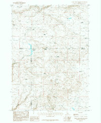
1986 Map of Thorn Creek Reservoir
USGS Topo · Published 1986About this map
Macon Flat occupies the northwestern corner of this mid-1980s landscape, where three Idaho counties—Camas, Gooding, and Lincoln—converge. The terrain is defined by a sophisticated network of water management, illustrated by numerous impoundments including Thorn Creek Reservoir, Divide Reservoir, and Snake Reservoir. These features, alongside the meandering Thorn Creek, reveal a high-desert environment engineered for livestock or agricultural support. Named water sources such as Barrel Water Hole, Middle Water Hole, and Uphill Water Hole are scattered across the high ground, serving as critical landmarks in an otherwise open range. To the south, the relief deepens significantly into Rattlesnake Canyon and Preacher Gulch, while Timber Gulch leads toward the drainage of Portuguese Creek. This survey captures the region just as modern mapping transitions were beginning, preserving the locations of springs like Eusebio Spring and Rattlesnake Spring that have long anchored local land use.
Find a feature on this map
23 named features on this map. Tap any name to fly to it.
Don’t see what you’re looking for? This feature index may not catch every label — zoom into the map to look around manually.
Map Details
Editions of this 1986 Thorn Creek Reservoir Map
This is the sole edition of this map. No revisions or reprints were ever made.
Other maps of this area

1955 · Hailey
USGS Topo · 1:250,000

1957 · Thorn Creek SE
USGS Topo · 1:24,000

1957 · Thorn Creek SW
USGS Topo · 1:24,000

1957 · Thorn Creek
USGS Topo · 1:62,500

1957 · Bellevue
USGS Topo · 1:62,500

1957 · Blaine
USGS Topo · 1:62,500

1959 · Hailey
USGS Topo · 1:250,000

1962 · Hailey
USGS Topo · 1:250,000

1979 · Summit Reservoir
USGS Topo · 1:24,000
1979 · Mammoth Cave
USGS Topo · 1:24,000