1970s Maps of Cassia County, Idaho
Explore 8 historic maps of Cassia County from the 1970s. These maps offer a rare glimpse into what life looked like during the 1970s — showing old roads, neighborhoods, homes, and landmarks that have changed or disappeared over time.
Whether you're researching your family's past, planning a metal detecting trip, or studying how Cassia County's landscape evolved across the 1970s, these high-resolution maps are a powerful tool for exploring the history of this region.
- Focus on a specific era: All maps on this page are from the 1970s, giving you a focused view of this time period.
- See what’s changed: Compare century-old streets, trails, and buildings to today's modern landscape using overlays and satellite layers.
- Research with precision: Use these maps for genealogy, historical research, land use analysis, or educational projects.
- View, download, or print: Maps are fully viewable online in high resolution, and can be downloaded or printed for your own records.
Start exploring Cassia County's history through authentic maps from the 1970s. This is your window into the past.
Cassia County, ID maps
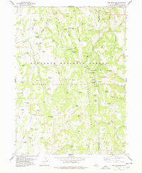
(8)- 1973 Map of Sublett Troughs, 1976 Print
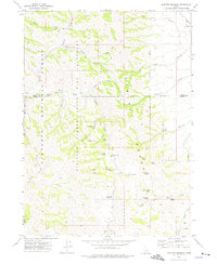 1973 Sublett Troughs1976 Print · USGSOneida County's high country is preserved here in the 1970s, showing a landscape of state bird sanctuaries and national forest lands. Local historians can trace old routes through Summit Springs Pass and locate remote sites like the Sublett Forest Service Station and Pine Creek Reservoir.
 - 1977 Map of Timber Butte
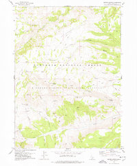
 1977 Timber Butte1977 Print · USGSThe Idaho and Nevada borderlands come into focus during the late seventies, showing the intersection of high-country forests and basin springs. Researchers can trace the water-scarce economy of the day through landmarks like Japanese Spring, Basque Spring, and the high summit of Timber Butte.
 - 1977 Map of Mahogany Butte, 1978 Print
 1977 Mahogany Butte1978 Print · USGSThe high-desert borderlands of southern Idaho and northern Nevada are shown in the 1970s before modern development. Researchers can trace remote livestock routes and conservation boundaries via Jay Creek Corral, WPA Spring, and the Minidoka State Bird Sanctuary.
 - 1977 Map of Ibex Peak, 1978 Print
 1977 Ibex Peak1978 Print · USGSThe high borderlands where Idaho, Nevada, and Utah meet are captured here in the late 1970s, showcasing a landscape of remote mountain peaks and vital desert water sources. Researchers can trace historic ranching sites like Wards Corral and the Worthington Mine, or locate family-named landmarks including Emery Ranch and Frish Ranch.2 unique versions available
 - 1978 Map of Pike Mountain
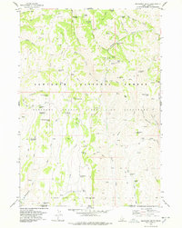
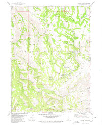
 1978 Pike Mountain1978 Print · USGSSouthern Idaho’s high forest lands are captured here in the late seventies, showing a landscape dedicated to forestry and alpine recreation. Genealogists and historians can trace old forest outposts like the Shoshone Cabin or locate early recreation sites like the Magic Mtn Ski Area and Kum Ba Yah Camp.2 unique versions available
 - 1978 Map of Severe Spring
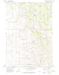
 1978 Severe Spring1978 Print · USGSThe Cassia County backcountry in the late seventies is characterized by high forest ridges and essential water sources for remote ranching. Researchers can trace the network of jeep trails and pack trails connecting landmarks like Terrells Corral, Durfee Meadow, and Severe Spring.
 - 1979 Map of Trapper Peak
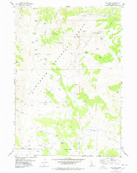
 1979 Trapper Peak1979 Print · USGSThe high Idaho backcountry of the late seventies is captured here, showing a landscape defined by federal conservation and high-peak topography. Researchers can trace historic access routes like the Martindale Trail and locate remote outposts such as the Bostetter Forest Service Station.
 - 1979 Map of Stricker Butte, 1980 Print
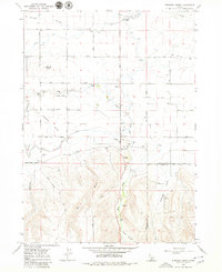 1979 Stricker Butte1980 Print · USGSNear the Twin Falls and Cassia county line during the late seventies, this survey captures the intersection of irrigated agriculture and high-desert ranching. Researchers can locate the Stricker Cabin, trace the High Line Canal, and identify local landmarks like the Rock Creek Cemeteries.2 unique versions available
End of results
Showing maps 1-8 of 8
Top cities of Cassia County
- Burley historical maps
- Oakley historical maps
- Declo historical maps
- Albion historical maps
- Malta historical maps
Frequently asked questions
- What are the different types of historical maps available for Cassia County?
- What is the oldest map of Cassia County?
- Where can I purchase historical maps of Cassia County for my home or office?
- Where can I download high-res historical maps of Cassia County?
- Are there historical topographic maps available for Cassia County?
- Is there historical aerial imagery available for Cassia County?
- Where are historical maps of Cassia County sourced from?