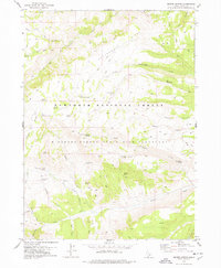
1978 Map of Severe Spring
USGS Topo · Published 1978About this map
Minidoka Forest State Bird Sanctuary and the Sawtooth National Forest dominate this high-elevation landscape in Cassia County, Idaho. The terrain is defined by a dense network of hydrologic features and steep topographic relief, including Hudson Ridge and Cottonwood Ridge. A complex system of named springs, such as Severe Spring, Big Pipe Spring, and Chokecherry Spring, indicates the importance of water management for livestock in this arid forest environment. Evidence of historical land use and ranching is scattered throughout the region, marked by sites like Terrells Corral and the broad opening of Durfee Meadow. Transport across these ridges in the late 1970s relied on a lattice of unimproved tracks, including various pack trails and jeep trails that navigate the drainages of Squaw Creek and Trapper Creek.
Find a feature on this map
41 named features on this map. Tap any name to fly to it.
Don’t see what you’re looking for? This feature index may not catch every label — zoom into the map to look around manually.
Map Details
Editions of this 1978 Severe Spring Map
This is the sole edition of this map. No revisions or reprints were ever made.
Other maps of this area

1954 · Pocatello
USGS Topo · 1:250,000

1955 · Twin Falls
USGS Topo · 1:250,000

1958 · Twin Falls
USGS Topo · 1:250,000

1958 · Pocatello
USGS Topo · 1:250,000

1965 · Rams Horn Ridge
USGS Topo · 1:24,000

1965 · Buckhorn Canyon
USGS Topo · 1:24,000
1968 · Blue Hill
USGS Topo · 1:24,000
1968 · Oakley
USGS Topo · 1:24,000
1968 · Marion
USGS Topo · 1:24,000

1977 · Mahogany Butte
USGS Topo · 1:24,000