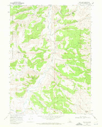
1968 Map of Blue Hill
USGS Topo · Published 1972About this map
California Trail and Applegate Trail corridors intersect the southern portion of this landscape, marking historic overland migration routes through the high desert. Recorded in the late 1960s, the terrain is defined by a dense network of drainages and springs within the Sawtooth National Forest. Significant water sources like Poulton Spring, Wilson Spring, and the geothermal Spring (Hot) are plotted along the northern canyons. These natural features, along with Coal Banks Spring and its associated Mine, highlight a history of livestock grazing and early mineral extraction. The map detail follows the path of Goose Creek as it winds through Big Canyon and past the distinctive height of Blue Hill, showing the complex topography and sparse jeep trails that characterize this remote Idaho backcountry during the mid-20th century.
Find a feature on this map
30 named features on this map. Tap any name to fly to it.
Don’t see what you’re looking for? This feature index may not catch every label — zoom into the map to look around manually.
Map Details
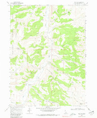
Editions of this 1968 Blue Hill Map
2 editions found
Other maps of this area

1954 · Pocatello
USGS Topo · 1:250,000

1954 · Brigham City
USGS Topo · 1:250,000

1955 · Twin Falls
USGS Topo · 1:250,000

1955 · Wells
USGS Topo · 1:250,000

1958 · Wells
USGS Topo · 1:250,000

1958 · Twin Falls
USGS Topo · 1:250,000

1958 · Pocatello
USGS Topo · 1:250,000

1958 · Brigham City
USGS Topo · 1:250,000

1959 · Cotton Thomas Basin
USGS Topo · 1:62,500

1961 · Wells
USGS Topo · 1:250,000