2000-2009 Maps of Oakley, Idaho
Explore 3 historic maps of Oakley from 2000-2009. These maps offer a rare glimpse into what life looked like during the 2000s — showing old roads, neighborhoods, homes, and landmarks that have changed or disappeared over time.
Whether you're researching your family's past, planning a metal detecting trip, or studying how Oakley's landscape evolved across the 2000s, these high-resolution maps are a powerful tool for exploring the history of this region.
- Focus on a specific era: All maps on this page are from the 2000s, giving you a focused view of this time period.
- See what’s changed: Compare century-old streets, trails, and buildings to today's modern landscape using overlays and satellite layers.
- Research with precision: Use these maps for genealogy, historical research, land use analysis, or educational projects.
- View, download, or print: Maps are fully viewable online in high resolution, and can be downloaded or printed for your own records.
Start exploring Oakley's history through authentic maps from the 2000s. This is your window into the past.
Oakley, ID maps
(3)- 2001 Map of Basin, 2006 Print
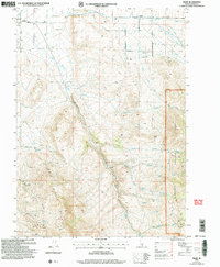 2001 Basin2006 Print · USGSOakley and the surrounding high country of Cassia County are captured here just after the turn of the twenty-first century. Researchers can trace land use from the Basin Cem to the industrial footprints of Fish Creek Quarry and Camel Rock within the Sawtooth National Forest.
 - 2001 Map of Oakley, 2006 Print
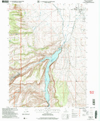 2001 Oakley2006 Print · USGSOakley and the surrounding Goose Creek valley are shown here at the start of the twenty-first century, centered on the vital water management systems of the high desert. Researchers can trace the local irrigation network through the West Canal and aqueduct, or locate civic landmarks like the Cemetery and Rodeo Ground.
 - 2001 Map of Marion, 2006 Print
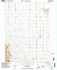 2001 Marion2006 Print · USGSCassia County at the start of the millennium reveals a landscape of irrigation and memory, where high desert farmland meets the SAWTOOTH NATIONAL FOREST. Trace vanished settlements and rail sidings like Churchill (Site), Locust, and Warr (Site), or locate family roots at the Marion Cemetery.
End of results
Showing maps 1-3 of 3
Frequently asked questions
- What are the different types of historical maps available for Oakley?
- What is the oldest map of Oakley?
- Where can I purchase historical maps of Oakley for my home or office?
- Where can I download high-res historical maps of Oakley?
- Are there historical topographic maps available for Oakley?
- Is there historical aerial imagery available for Oakley?
- Where are historical maps of Oakley sourced from?