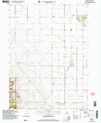
2001 Map of Marion
USGS Topo · Published 2006About this map
The agrarian landscape of southern Idaho unfolds across this survey, marked by the irrigation patterns of Goose Creek and an extensive network of wells. At the turn of the 21st century, the map documents several vanished settlements and former rail locations, such as Churchill (Site) and its corresponding Churchill (Siding Site). These "site" designations reveal a transitioning rural economy where once-active communities like Trout (Site) and Warr (Site) have faded from the map while smaller hubs like Marion and Island persist. The southwestern corner is defined by the steep elevation of the Sawtooth National Forest, including Big Hollow, which contrasts sharply with the flat, canal-fed farmland to the east. Genealogists will find precision in the locations of the Island Cemetery and Marion Cemetery, alongside distinctive geological features like the volcanic uplift of The Knolls.
Find a feature on this map
27 named features on this map. Tap any name to fly to it.
Don’t see what you’re looking for? This feature index may not catch every label — zoom into the map to look around manually.
Map Details
Editions of this 2001 Marion Map
This is the sole edition of this map. No revisions or reprints were ever made.
Other maps of this area

1954 · Pocatello
USGS Topo · 1:250,000

1955 · Twin Falls
USGS Topo · 1:250,000

1958 · Twin Falls
USGS Topo · 1:250,000

1958 · Pocatello
USGS Topo · 1:250,000

1964 · Kenyon
USGS Topo · 1:24,000

1964 · Burley Butte
USGS Topo · 1:24,000

1965 · Milner Butte
USGS Topo · 1:24,000

1965 · Buckhorn Canyon
USGS Topo · 1:24,000

1968 · Basin
USGS Topo · 1:24,000

1968 · Marion SE
USGS Topo · 1:24,000