
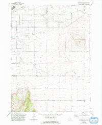
1965 Map of Milner Butte
USGS Topo · Published 1966About this map
Main Canal and an extensive network of siphons, aqueducts, and pipelines dominate this 1960s landscape, illustrating the critical role of water management in the high desert of the Snake River Plain. The engineering infrastructure is anchored by facilities such as Pumping Station 10 and the Lake Substation, which supported agricultural expansion in the mid-20th century. Terrain features like Milner Butte provide significant vertical relief against the surrounding section-line roads, including Milner Low Lift Road and 2900 North Road. Small-scale industrial activity is evidenced by several Gravel Pits located near the southern boundary. To the west, the spillway of Murtaugh Lake marks a key water body on the Twin Falls and Cassia County line, while Cottonwood Creek and Mountain Meadow Creek drain the higher elevations in the southwest.
Find a feature on this map
20 named features on this map. Tap any name to fly to it.
Don’t see what you’re looking for? This feature index may not catch every label — zoom into the map to look around manually.
Map Details
Editions of this 1965 Milner Butte Map
2 editions found
Other maps of this area

1954 · Pocatello
USGS Topo · 1:250,000

1955 · Twin Falls
USGS Topo · 1:250,000

1958 · Twin Falls
USGS Topo · 1:250,000

1958 · Pocatello
USGS Topo · 1:250,000

1964 · Burley SW
USGS Topo · 1:24,000

1964 · Eden
USGS Topo · 1:24,000

1964 · Milner
USGS Topo · 1:24,000

1964 · Burley Butte
USGS Topo · 1:24,000

1965 · Rams Horn Ridge
USGS Topo · 1:24,000

1965 · Murtaugh
USGS Topo · 1:24,000