1980s Maps of Clark County, Idaho
Explore 18 historic maps of Clark County from the 1980s. These maps offer a rare glimpse into what life looked like during the 1980s — showing old roads, neighborhoods, homes, and landmarks that have changed or disappeared over time.
Whether you're researching your family's past, planning a metal detecting trip, or studying how Clark County's landscape evolved across the 1980s, these high-resolution maps are a powerful tool for exploring the history of this region.
- Focus on a specific era: All maps on this page are from the 1980s, giving you a focused view of this time period.
- See what’s changed: Compare century-old streets, trails, and buildings to today's modern landscape using overlays and satellite layers.
- Research with precision: Use these maps for genealogy, historical research, land use analysis, or educational projects.
- View, download, or print: Maps are fully viewable online in high resolution, and can be downloaded or printed for your own records.
Start exploring Clark County's history through authentic maps from the 1980s. This is your window into the past.
Clark County, ID maps
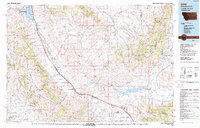
(18)- 1980 Map of Circular Butte
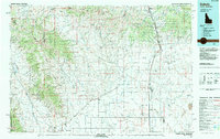
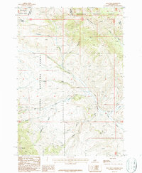
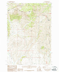
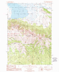
 1980 Circular Butte1980 Print · USGSEastern Idaho at the start of the eighties shows a landscape of federal research and agricultural expansion. Trace the growth of nuclear history at the Idaho National Engineering Laboratory and early settlements like Monteview, Terreton, and Sage Junction.
 - 1983 Map of Dubois
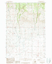
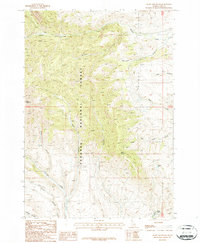
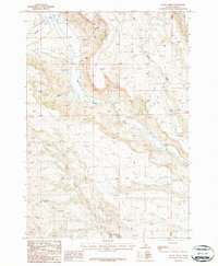
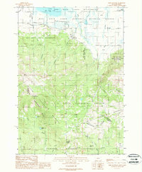
 1983 Dubois1983 Print · USGSEastern Idaho's high-country ranching and research landscape is captured here in the early 1980s. Local researchers can trace the Union Pacific line through Dubois, locate the sprawling U S Sheep Experiment Station, or find the former location of Winsper (Site).
 - 1987 Map of Thunder Gulch
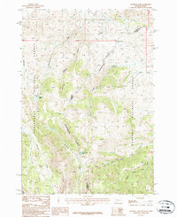
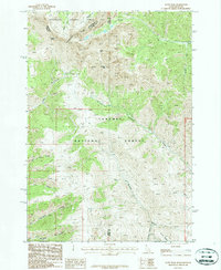
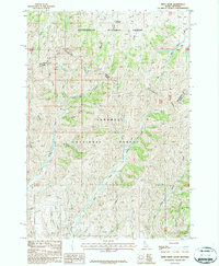
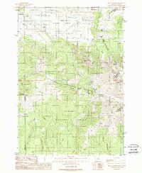
 1987 Thunder Gulch1987 Print · USGSHigh-altitude Idaho forest land meets the arid basin in the late eighties, showing a landscape defined by its remote drainages and early water works. Trace the paths of Thunder Gulch and Patzick Ditch alongside landmarks like Hoolie Springs.
 - 1987 Map of Deadman Lake
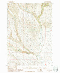
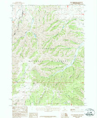
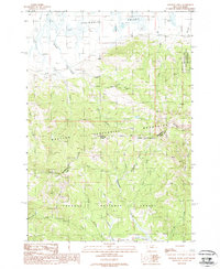
 1987 Deadman Lake1987 Print · USGSThe high mountain crest between Montana and Idaho is captured here in the late 1980s, centered on the Continental Divide. Researchers can trace the hydrological separation at Bannock Pass and locate remote water bodies like Deadman Lake and Divide Creek Lake.
 - 1987 Map of Indian Creek
 1987 Indian Creek1987 Print · USGSHigh desert ranching and water rights define this corner of Clark County during the 1980s. Researchers can locate a remote Cem, trace the drainage of Middle Fork Medicine Lodge Creek, and identify early agricultural markers like Grain Bins near Indian Creek Butte.
 - 1987 Map of Fritz Peak
 1987 Fritz Peak1987 Print · USGSHigh in the Beaverhead Mountains during the late eighties, this topography tracks the border between Idaho and Montana along the Continental Divide. Geologists and researchers can trace drainage patterns from Fritz Peak to remote Quarries and Prospects tucked into canyons like Poison Canyon.
 - 1987 Map of Lima
 1987 Lima1987 Print · USGSThe high mountain passes of the Montana-Idaho border come alive in the late eighties as they follow the historic rail and road corridors. You can trace the Union Pacific line through Lima and Monida or locate the Silver Queen Mine in the northern ranges.
 - 1987 Map of Heart Mountain
 1987 Heart Mountain1987 Print · USGSThe high mountain country of Clark County is documented in the late eighties, showing a landscape defined by mineral exploration and forest boundaries. Researchers can locate several prospects and trace drainages like Webber Creek and Slate Creek.
 - 1987 Map of Scott Peak
 1987 Scott Peak1987 Print · USGSThe Idaho-Montana borderlands are captured here in the late twentieth century, dominated by high-altitude peaks and the Continental Divide. Trace the remote terrain through Scott Peak, find the site of a Radio Tower, and follow the deep cuts of Nicholia Canyon.
 - 1987 Map of Edie Creek
 1987 Edie Creek1987 Print · USGSThe high mountain border between Idaho and Montana is captured here in the late eighties, dominated by the Continental Divide. Researchers can trace the headwaters of Medicine Lodge Creek and locate landmarks like Red Conglomerate Peaks and Edie Spring.
 - 1987 Map of Rocky Creek
 1987 Rocky Creek1987 Print · USGSThe high mountain terrain of Clark County is captured here in the late eighties as a land of rugged watercourses and essential utility corridors. A researcher can trace the paths of Medicine Lodge Creek and Edie Creek or locate landmarks like the South Fork Deep Creek.
 - 1987 Map of Tepee Draw
 1987 Tepee Draw1987 Print · USGSThe high mountain border between Idaho and Montana comes alive in the late eighties, tracing where the Beaverhead National Forest meets the Targhee National Forest. Local history researchers can locate the Middle Creek Cow Camp and follow old tracks through Tepee Draw.
 - 1987 Map of Paul Reservoir
 1987 Paul Reservoir1987 Print · USGSThe high country of the Idaho-Montana border is captured here in the late twentieth century, centered on the Targhee National Forest. Researchers can trace the Continental Divide and locate remote land-use sites like the local Headquarters and Paul Reservoir.
 - 1988 Map of Upper Red Rock Lake
 1988 Upper Red Rock Lake1988 Print · USGSThe high Montana-Idaho borderlands come into focus in the late 1980s, centered on the protected waters of the Red Rock Lakes National Wildlife Refuge. Researchers and historians can trace high-altitude land use from an Open Pit Mine to the US Sheep Experiment Station.2 unique versions available
 - 1988 Map of Slide Mountain
 1988 Slide Mountain1988 Print · USGSThe Centennial Valley and the high peaks of the Continental Divide meet in this late 1980s study of the Montana-Idaho border. Researchers can trace the layout of the U S Sheep Experiment Station and the settlement at Lakeview near the Red Rock Lakes Refuge.
 - 1988 Map of Mount Jefferson
 1988 Mount Jefferson1988 Print · USGSThe Montana-Idaho borderlands in the late eighties are defined here by high-mountain divides and federal land management. Outdoor historians and researchers can trace the reaches of the United States Sheep Experiment Station and remote water sources like Fruin Spring and Blair Lake.
 - 1988 Map of Winslow Creek
 1988 Winslow Creek1988 Print · USGSHigh-altitude wilderness along the Montana and Idaho border is documented here in the late eighties, centered on the Continental Divide. Researchers can trace the remote 7L Ranch, find a high-country Coal Mine, and locate the small Cem near the valley floor.
 - 1989 Map of Ashton
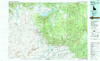 1989 Ashton1989 Print · USGSEastern Idaho at the end of the 1980s is captured here as a landscape of river-fed agriculture and high-altitude wilderness. Researchers can trace the Union Pacific line through Ashton and find old settlements like Kilgore and Idmon near the Targhee National Forest border.2 unique versions available
End of results
Showing maps 1-18 of 18
Top cities of Clark County
Frequently asked questions
- What are the different types of historical maps available for Clark County?
- What is the oldest map of Clark County?
- Where can I purchase historical maps of Clark County for my home or office?
- Where can I download high-res historical maps of Clark County?
- Are there historical topographic maps available for Clark County?
- Is there historical aerial imagery available for Clark County?
- Where are historical maps of Clark County sourced from?