1900s (20th Century) Maps of Weippe, Idaho
Explore 10 historic maps of Weippe from the 1900s (20th Century). These maps offer a rare glimpse into what life looked like during the 1900s — showing old roads, neighborhoods, homes, and landmarks that have changed or disappeared over time.
Whether you're researching your family's past, planning a metal detecting trip, or studying how Weippe's landscape evolved across the 1900s, these high-resolution maps are a powerful tool for exploring the history of this region.
- Focus on a specific era: All maps on this page are from the 1900s, giving you a focused view of this time period.
- See what’s changed: Compare century-old streets, trails, and buildings to today's modern landscape using overlays and satellite layers.
- Research with precision: Use these maps for genealogy, historical research, land use analysis, or educational projects.
- View, download, or print: Maps are fully viewable online in high resolution, and can be downloaded or printed for your own records.
Start exploring Weippe's history through authentic maps from the 1900s. This is your window into the past.
Weippe, ID maps
(10)- 1924 Map of Weippe
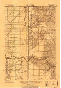 1924 Weippe1924 Print · USGSNorth-central Idaho in the early 1920s is captured here, from the prairie settlements to the deep river canyons of the Clearwater. Genealogists can trace early homesteaders like G.W. Ford or locate long-gone post offices at Tahoe and Lowell.
 - 1956 Map of Hamilton, 1970 Print
 1956 Hamilton1970 Print · USGSThe Bitterroot Valley and surrounding high country are captured here during the mid-fifties, showing the region's transition into a modern forest-and-rail hub. Genealogists and historians can trace family-named sites and early infrastructure from Fort Missoula to towns like Stevensville and Darby along the Northern Pacific line.2 unique versions available
 - 1959 Map of Hamilton
 1959 Hamilton1959 Print · USGSThe Bitterroot Valley and surrounding wilderness are captured in the late fifties, showing a landscape defined by forestry and river-based settlement. Researchers can trace the Lolo Trail or locate historical points like Fort Missoula and the Fred Burr Reservoir.
 - 1960 Map of Hamilton
 1960 Hamilton1960 Print · USGSThe Bitterroot Valley and surrounding high country are captured here during the late fifties, showing the region's transition into a modern forest and rail corridor. Researchers can trace the path of the Northern Pacific through Missoula or locate landmarks like Fort Missoula and Lake Como.
 - 1964 Map of Hamilton
 1964 Hamilton1964 Print · USGSThe Bitterroot Valley and its surrounding peaks are captured in detail during the mid-1960s, showing the early infrastructure of the Northern Rockies. Genealogists and historians can trace family roots in Hamilton and Stevensville or follow the historic Lolo Trail and Nez Perce Trail.
 - 1966 Map of Weippe South, 1968 Print
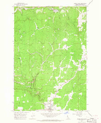
 1966 Weippe South1968 Print · USGSClearwater County at the edge of the national forest is captured here in the mid-sixties, where the open Weippe Prairie meets the timbered breaks. Researchers can locate the Weippe Cemetery, trace the Wilson Trail, and find the small settlement at Caribel near the Idaho County line.2 unique versions available
 - 1966 Map of Weippe North, 1968 Print
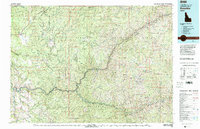
 1966 Weippe North1968 Print · USGSClearwater County timber and prairie lands are captured here in the mid-sixties as the lumber industry shaped the local geography. Researchers can trace the heritage of the region's logging through several specific sites like Battles Mill, Johnsons Mill, and the settlement of Omill.2 unique versions available
 - 1981 Map of Kooskia
 1981 Kooskia1981 Print · USGSNorthern Idaho in the early eighties shows a landscape of deep river canyons and high forest ridges. Researchers can locate remote mining sites like Hemlock Mine, the mountain settlement of Lowell, and the Kooskia National Fish Hatchery.
 - 1994 Map of Weippe South, 1997 Print
 1994 Weippe South1997 Print · USGSThe Clearwater high country in the mid-1990s reveals a landscape defined by timbered ridges and the historic Lewis and Clark National Historic Trail. Researchers can trace the Nez Perce Indian Reservation Boundary and locate family-named points like Jacobson and Caribel.
 - 1994 Map of Weippe North, 1997 Print
 1994 Weippe North1997 Print · USGSClearwater County's timber-driven landscape is captured here in the mid-1990s as the industry shaped the local geography. Researchers can trace the heritage of Weippe through its numerous lumber sites, including the Medley Cedar Mill, Timberline High School, and historical locations like Battles Mill (Site).
End of results
Showing maps 1-10 of 10
Top cities near Weippe
Frequently asked questions
- What are the different types of historical maps available for Weippe?
- What is the oldest map of Weippe?
- Where can I purchase historical maps of Weippe for my home or office?
- Where can I download high-res historical maps of Weippe?
- Are there historical topographic maps available for Weippe?
- Is there historical aerial imagery available for Weippe?
- Where are historical maps of Weippe sourced from?