1900s (20th Century) Maps of Pine, Idaho
Explore 5 historic maps of Pine from the 1900s (20th Century). These maps offer a rare glimpse into what life looked like during the 1900s — showing old roads, neighborhoods, homes, and landmarks that have changed or disappeared over time.
Whether you're researching your family's past, planning a metal detecting trip, or studying how Pine's landscape evolved across the 1900s, these high-resolution maps are a powerful tool for exploring the history of this region.
- Focus on a specific era: All maps on this page are from the 1900s, giving you a focused view of this time period.
- See what’s changed: Compare century-old streets, trails, and buildings to today's modern landscape using overlays and satellite layers.
- Research with precision: Use these maps for genealogy, historical research, land use analysis, or educational projects.
- View, download, or print: Maps are fully viewable online in high resolution, and can be downloaded or printed for your own records.
Start exploring Pine's history through authentic maps from the 1900s. This is your window into the past.
Pine, ID maps
(5)- 1955 Map of Hailey, 1968 Print
 1955 Hailey1968 Print · USGSCentral Idaho in the mid-fifties reveals a landscape transitioning from deep-rooted silver mining to a burgeoning outdoor economy. Researchers can trace the legacy of the Union Pacific line, the remote Triumph Mine, and original airfield layouts at Mountain Home Air Force Base.4 unique versions available
 - 1959 Map of Hailey
 1959 Hailey1959 Print · USGSThe Sawtooth range and high desert plains of Southern Idaho are captured here during a period of mining and military growth. Genealogists and historians can locate mining sites like Triumph Mine, early settlements such as Idaho City, and the Mountain Home Air Force Base.2 unique versions available
 - 1962 Map of Hailey
 1962 Hailey1962 Print · USGSCentral Idaho in the early sixties showcases a landscape of high-altitude ranching and mining at the foot of the Sawtooth Mountains. Genealogists and historians can trace the rail-and-river economy through the Union Pacific Railroad corridor and explore old mining sites like the Triumph Mine or Silver Star Queens Mine.
 - 1973 Map of Pine, 1977 Print
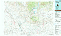
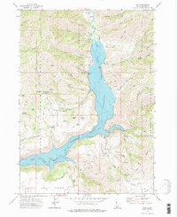 1973 Pine1977 Print · USGSElmore County's mountain canyon country is captured in the early 1970s as the river valleys adapt to the presence of large-scale reservoirs. Researchers can locate the Cem near Pine, trace the footprint of the Franklin Mine, and explore remote landmarks like Sloans.2 unique versions available
 - 1990 Map of Mountain Home, 1991 Print
 1990 Mountain Home1991 Print · USGSElmore County underwent significant expansion in the 1990s as military and transit networks matured between the mountains and the Snake River Plain. Researchers can trace the legacy of regional development through sites like Reclamation Village, the Union Pacific line, and Mountain Home Air Force Base.2 unique versions available
End of results
Showing maps 1-5 of 5
Frequently asked questions
- What are the different types of historical maps available for Pine?
- What is the oldest map of Pine?
- Where can I purchase historical maps of Pine for my home or office?
- Where can I download high-res historical maps of Pine?
- Are there historical topographic maps available for Pine?
- Is there historical aerial imagery available for Pine?
- Where are historical maps of Pine sourced from?