1980s Maps of Franklin County, Idaho
Explore 4 historic maps of Franklin County from the 1980s. These maps offer a rare glimpse into what life looked like during the 1980s — showing old roads, neighborhoods, homes, and landmarks that have changed or disappeared over time.
Whether you're researching your family's past, planning a metal detecting trip, or studying how Franklin County's landscape evolved across the 1980s, these high-resolution maps are a powerful tool for exploring the history of this region.
- Focus on a specific era: All maps on this page are from the 1980s, giving you a focused view of this time period.
- See what’s changed: Compare century-old streets, trails, and buildings to today's modern landscape using overlays and satellite layers.
- Research with precision: Use these maps for genealogy, historical research, land use analysis, or educational projects.
- View, download, or print: Maps are fully viewable online in high resolution, and can be downloaded or printed for your own records.
Start exploring Franklin County's history through authentic maps from the 1980s. This is your window into the past.
Franklin County, ID maps
(4)- 1983 Map of Preston
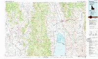 1983 Preston1983 Print · USGSSoutheast Idaho and the tri-state border region thrived on a mix of mountain agriculture and rail transport in the early eighties. Genealogists and historians can trace the Union Pacific corridor through Preston or locate family landmarks in Mound Valley and Paris.
 - 1984 Map of Malad City
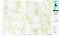 1984 Malad City1984 Print · USGSSoutheastern Idaho in the mid-eighties shows a landscape of high valleys and prominent ranges between the Malad and Curlew basins. Genealogists and historians can trace the foundations of local ranching communities like Samaria, Holbrook, and Arbon, or locate the Black Pine Bird Sanctuary.2 unique versions available
 - 1984 Map of Logan, 1985 Print
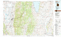 1984 Logan1985 Print · USGSNorthern Utah and its borderlands with Idaho and Wyoming are shown here in the mid-1980s as the Cache Valley communities grew. Researchers can trace the Union Pacific rail lines and find legacy sites like College Ward, Pickleville, and Utah State University.3 unique versions available
 - 1989 Map of Tremonton
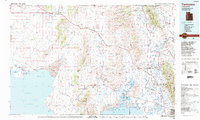 1989 Tremonton1989 Print · USGSNorthern Utah and the Idaho borderlands appear here in the late eighties, centered on the historic rail corridor and the fertile Bear River valley. Genealogists and historians can trace the legacy of settlements from Washakie to Honeyville and the Golden Spike National Historic Site.2 unique versions available
End of results
Showing maps 1-4 of 4
Top cities of Franklin County
- Preston historical maps
- Franklin historical maps
- Dayton historical maps
- Weston historical maps
- Clifton historical maps
- Oxford historical maps
Frequently asked questions
- What are the different types of historical maps available for Franklin County?
- What is the oldest map of Franklin County?
- Where can I purchase historical maps of Franklin County for my home or office?
- Where can I download high-res historical maps of Franklin County?
- Are there historical topographic maps available for Franklin County?
- Is there historical aerial imagery available for Franklin County?
- Where are historical maps of Franklin County sourced from?