1990s Maps of Franklin County, Idaho
Explore 3 historic maps of Franklin County from the 1990s. These maps offer a rare glimpse into what life looked like during the 1990s — showing old roads, neighborhoods, homes, and landmarks that have changed or disappeared over time.
Whether you're researching your family's past, planning a metal detecting trip, or studying how Franklin County's landscape evolved across the 1990s, these high-resolution maps are a powerful tool for exploring the history of this region.
- Focus on a specific era: All maps on this page are from the 1990s, giving you a focused view of this time period.
- See what’s changed: Compare century-old streets, trails, and buildings to today's modern landscape using overlays and satellite layers.
- Research with precision: Use these maps for genealogy, historical research, land use analysis, or educational projects.
- View, download, or print: Maps are fully viewable online in high resolution, and can be downloaded or printed for your own records.
Start exploring Franklin County's history through authentic maps from the 1990s. This is your window into the past.
Franklin County, ID maps
(3)- 1998 Map of Richmond, 2001 Print
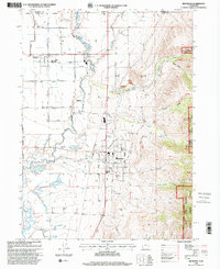 1998 Richmond2001 Print · USGSThe Cache Valley and the foothills of the Wasatch Range appear here as they were at the end of the century. Trace local family history and land use through landmarks like North Cache Jr HS, the Cub River, and the Mount Naomi Wilderness.
 - 1998 Map of Tony Grove Creek, 2001 Print
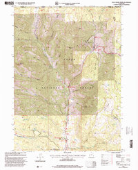 1998 Tony Grove Creek2001 Print · USGSThe high Bear River Range comes alive in the late nineties as a hub for both industry and recreation along the Idaho-Utah border. Researchers can find old mining sites like the Amazon Mine alongside the Beaver Mountain Ski Area and the Tony Grove Guard Sta.
 - 1998 Map of Naomi Peak, 2001 Print
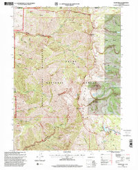 1998 Naomi Peak2001 Print · USGSThe high peaks of the Bear River Range at the turn of the millennium are meticulously detailed in this late-nineties survey. Hikers and historians can trace the paths around White Pine Lake, locate the Mine in Smithfield Canyon, and explore the glacial basins of the Mount Naomi Wilderness.
End of results
Showing maps 1-3 of 3
Top cities of Franklin County
- Preston historical maps
- Franklin historical maps
- Dayton historical maps
- Weston historical maps
- Clifton historical maps
- Oxford historical maps
Frequently asked questions
- What are the different types of historical maps available for Franklin County?
- What is the oldest map of Franklin County?
- Where can I purchase historical maps of Franklin County for my home or office?
- Where can I download high-res historical maps of Franklin County?
- Are there historical topographic maps available for Franklin County?
- Is there historical aerial imagery available for Franklin County?
- Where are historical maps of Franklin County sourced from?