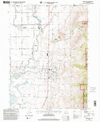
1998 Map of Richmond
USGS Topo · Published 2001About this map
The Cub River meanders through the Cache Valley landscape in this revision based on late-1990s data. The settlements of Lewiston and Richmond serve as the primary hubs, where a strictly organized grid of streets like Main Street and South Street give way to the complex irrigation and drainage network of the valley floor. To the east, the terrain rises sharply into the Cache National Forest and the Mount Naomi Wilderness, marked by distinctive features such as Richmond Knoll and Fraters Hollow. This map captures the intersection of intensive agriculture, evidenced by numerous Sewage Ponds and a Corral, with the protected mountain highlands. Local institutional life is anchored by landmarks like the North Cache Jr HS and multiple cemeteries, while the industrial footprint is noted through several Gravel Pits and a Sawmill Pit.
Find a feature on this map
48 named features on this map. Tap any name to fly to it.
Don’t see what you’re looking for? This feature index may not catch every label — zoom into the map to look around manually.
Map Details
Editions of this 1998 Richmond Map
This is the sole edition of this map. No revisions or reprints were ever made.
Other maps of this area

1914 · Logan
USGS Topo · 1:125,000

1915 · Preston
USGS Topo · 1:96,000

1916 · Logan
USGS Topo · 1:125,000

1918 · Preston
USGS Topo · 1:125,000

1954 · Ogden
USGS Topo · 1:250,000

1955 · Preston
USGS Topo · 1:250,000

1958 · Ogden
USGS Topo · 1:250,000

1958 · Preston
USGS Topo · 1:250,000

1960 · Ogden
USGS Topo · 1:250,000

1962 · Preston
USGS Topo · 1:250,000