1960s Maps of Franklin, Idaho
Explore 4 historic maps of Franklin from the 1960s. These maps offer a rare glimpse into what life looked like during the 1960s — showing old roads, neighborhoods, homes, and landmarks that have changed or disappeared over time.
Whether you're researching your family's past, planning a metal detecting trip, or studying how Franklin's landscape evolved across the 1960s, these high-resolution maps are a powerful tool for exploring the history of this region.
- Focus on a specific era: All maps on this page are from the 1960s, giving you a focused view of this time period.
- See what’s changed: Compare century-old streets, trails, and buildings to today's modern landscape using overlays and satellite layers.
- Research with precision: Use these maps for genealogy, historical research, land use analysis, or educational projects.
- View, download, or print: Maps are fully viewable online in high resolution, and can be downloaded or printed for your own records.
Start exploring Franklin's history through authentic maps from the 1960s. This is your window into the past.
Franklin, ID maps
(4)- 1960 Map of Ogden
 1960 Ogden1960 Print · USGSIn the mid-1950s, this region of the American West balanced military expansion with frontier history along the Union Pacific RR. Genealogists and historians can trace old settlements like Fort Bridger, the residential growth of Washington Terrace, and industrial sites from the Hill AFB complex to the coal mines of Kemmerer.
 - 1962 Map of Preston
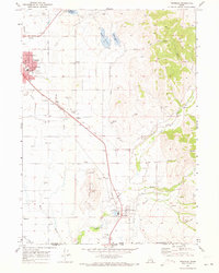
 1962 Preston1962 Print · USGSSoutheast Idaho and the Wyoming borderlands are captured here in the early sixties, a time of thriving agricultural valleys and mountain ranching. Researchers can trace the Union Pacific rail lines and find legacy settlements like Montpelier, Afton, and Preston.
 - 1964 Map of Richmond, 1966 Print
 1964 Richmond1966 Print · USGSThe northern Cache Valley comes alive in the mid-1960s, showing the agricultural heartland along the Idaho-Utah border. Genealogists and local historians can trace family land near Lewiston, the Sugar Refinery, and the Union Pacific rail lines.
 - 1969 Map of Franklin, 1973 Print
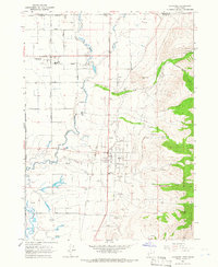
 1969 Franklin1973 Print · USGSFranklin and Preston were established agricultural hubs in the late sixties, tied together by the Union Pacific Railroad. You can trace old family roots and rural infrastructure through Whitney School, the Fairview Cemetery, and the Upper Canal.
End of results
Showing maps 1-4 of 4
Top cities near Franklin
- Logan historical maps
- North Logan historical maps
- Smithfield historical maps
- Preston historical maps
- Hyde Park historical maps
- Richmond historical maps
See more
Frequently asked questions
- What are the different types of historical maps available for Franklin?
- What is the oldest map of Franklin?
- Where can I purchase historical maps of Franklin for my home or office?
- Where can I download high-res historical maps of Franklin?
- Are there historical topographic maps available for Franklin?
- Is there historical aerial imagery available for Franklin?
- Where are historical maps of Franklin sourced from?