1900s (20th Century) Maps of Drummond, Idaho
Explore 10 historic maps of Drummond from the 1900s (20th Century). These maps offer a rare glimpse into what life looked like during the 1900s — showing old roads, neighborhoods, homes, and landmarks that have changed or disappeared over time.
Whether you're researching your family's past, planning a metal detecting trip, or studying how Drummond's landscape evolved across the 1900s, these high-resolution maps are a powerful tool for exploring the history of this region.
- Focus on a specific era: All maps on this page are from the 1900s, giving you a focused view of this time period.
- See what’s changed: Compare century-old streets, trails, and buildings to today's modern landscape using overlays and satellite layers.
- Research with precision: Use these maps for genealogy, historical research, land use analysis, or educational projects.
- View, download, or print: Maps are fully viewable online in high resolution, and can be downloaded or printed for your own records.
Start exploring Drummond's history through authentic maps from the 1900s. This is your window into the past.
Drummond, ID maps
(10)- 1955 Map of Ashton, 1967 Print
 1955 Ashton1967 Print · USGSThe Greater Yellowstone ecosystem is captured here during the mid-1950s, showing the high plateaus and remote gateway towns of Idaho and Montana. Researchers can trace the Union Pacific line to Ashton or locate small settlements like Squirrel and Grainville.4 unique versions available
 - 1955 Map of Driggs, 1967 Print
 1955 Driggs1967 Print · USGSEastern Idaho and Western Wyoming appear at a mid-century crossroads as the river valleys were fully settled and the high peaks protected. Genealogists and researchers can trace the rail towns of Rexburg and Driggs or follow the Snake River from Irwin to the Palisades Reservoir.3 unique versions available
 - 1958 Map of Driggs
 1958 Driggs1958 Print · USGSThe high Teton peaks and Snake River valleys are captured here in the mid-fifties, showing the region's agricultural and wilderness boundaries. Researchers can trace the Union Pacific rail corridor through Rexburg or locate early settlements like Clementsville and Tetonia.2 unique versions available
 - 1958 Map of Ashton
 1958 Ashton1958 Print · USGSGreater Yellowstone and the eastern Idaho borderlands appear here in the mid-1950s as rail and road networks connected remote mountain basins. Trace the Union Pacific route through Ashton or locate early outposts like Last Chance, Squirrel, and West Yellowstone.
 - 1960 Map of Ashton
 1960 Ashton1960 Print · USGSThe Idaho-Montana-Wyoming borderlands at the dawn of the sixties show a landscape defined by the Continental Divide and early wilderness tourism. Genealogists and historians can trace rail-stop settlements like Trude Siding, old outposts like Warm River, and early lodging at Snowball Inn.
 - 1962 Map of Driggs
 1962 Driggs1962 Print · USGSThe Idaho-Wyoming borderlands are captured here in the early sixties, showing the peaks and valleys of the northern Rockies. Genealogists and historians can trace rail lines like the Union Pacific RR and isolated outposts like the National Elk Refuge or the Fort Hall Indian Reservation.
 - 1965 Map of Drummond, 1967 Print
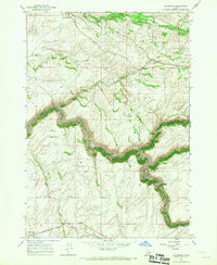 1965 Drummond1967 Print · USGSEastern Idaho's plateau and deep river canyons are captured here in the mid-sixties, showing the intersection of rail transport and hydroelectric power. Researchers can trace the Union Pacific line through Drummond or locate local landmarks like Farnum Cem and the Camp Henry Historic Site.2 unique versions available
 - 1965 Map of Warm River, 1967 Print
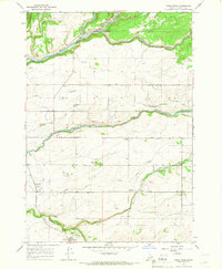 1965 Warm River1967 Print · USGSFremont County's river-driven landscape is captured here in the mid-sixties as agricultural canals and rail lines shaped the local economy. Researchers can trace the Union Pacific corridor through Grainville and Drummond, or locate family sites near the Squirrel Cemetery and Stephens Fish Cr Ranch.3 unique versions available
 - 1988 Map of Rexburg, 1989 Print
 1988 Rexburg1989 Print · USGSThe Upper Snake River Valley in the late eighties shows a region shaped by water and agriculture. Genealogists and historians can locate family plots at the Rexburg Cemetery or trace the early paths of the Union Pacific Railroad through towns like Sugar City and Newdale.
 - 1989 Map of Ashton
 1989 Ashton1989 Print · USGSEastern Idaho at the end of the 1980s is captured here as a landscape of river-fed agriculture and high-altitude wilderness. Researchers can trace the Union Pacific line through Ashton and find old settlements like Kilgore and Idmon near the Targhee National Forest border.2 unique versions available
End of results
Showing maps 1-10 of 10
Top cities near Drummond
Frequently asked questions
- What are the different types of historical maps available for Drummond?
- What is the oldest map of Drummond?
- Where can I purchase historical maps of Drummond for my home or office?
- Where can I download high-res historical maps of Drummond?
- Are there historical topographic maps available for Drummond?
- Is there historical aerial imagery available for Drummond?
- Where are historical maps of Drummond sourced from?