1900s (20th Century) Maps of Riggins, Idaho
Explore 7 historic maps of Riggins from the 1900s (20th Century). These maps offer a rare glimpse into what life looked like during the 1900s — showing old roads, neighborhoods, homes, and landmarks that have changed or disappeared over time.
Whether you're researching your family's past, planning a metal detecting trip, or studying how Riggins's landscape evolved across the 1900s, these high-resolution maps are a powerful tool for exploring the history of this region.
- Focus on a specific era: All maps on this page are from the 1900s, giving you a focused view of this time period.
- See what’s changed: Compare century-old streets, trails, and buildings to today's modern landscape using overlays and satellite layers.
- Research with precision: Use these maps for genealogy, historical research, land use analysis, or educational projects.
- View, download, or print: Maps are fully viewable online in high resolution, and can be downloaded or printed for your own records.
Start exploring Riggins's history through authentic maps from the 1900s. This is your window into the past.
Riggins, ID maps
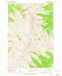
(7)- 1938 Map of Riggins
 1938 Riggins1938 Print · USGSRiggins and the canyon of the Salmon River appear here in the late 1930s, showing a landscape defined by mining, ranching, and forest management. Genealogists and historians can trace family-named sites like McMillians Mine, the Black Bear Inn, and the Middle District School.2 unique versions available
 - 1945 Map of Riggins
 1945 Riggins1945 Print · USGSRiggins and the deep river canyons of central Idaho are captured here just before the mid-century, showing the isolated ranching and forest-service life of the era. Researchers can locate remote homesteads and outposts like Hinkley Cabin, the Middle District Sch, and Old Pollock.
 - 1955 Map of Grangeville, 1964 Print
 1955 Grangeville1964 Print · USGSThe high country of the Idaho-Oregon border comes alive in the mid-1950s, showing the deep river canyons and mountain peaks. Trace the Union Pacific RR through the valleys or locate settlements like Grangeville, Joseph, and the shoreline of Wallowa Lake.4 unique versions available
 - 1959 Map of Grangeville
 1959 Grangeville1959 Print · USGSThe high alpine peaks and deep river canyons of the Idaho-Oregon borderlands are captured in the late fifties. Researchers can trace the Union Pacific RR through the valleys to settlements like Enterprise, Union, and Grangeville.2 unique versions available
 - 1964 Map of Riggins, 1965 Print
 1964 Riggins1965 Print · USGSRiggins serves as a vital river-junction hub in the mid-1960s, situated where the major forks of the Salmon meet deep in the canyon. Genealogists and local historians can trace the town's footprint including the Salmon River High Sch, the Salmon River Landing Strip, and named heights like Preacher Mountain.2 unique versions available
 - 1987 Map of Riggins
 1987 Riggins1987 Print · USGSThe Salmon and Snake River canyons defined the Idaho-Oregon borderlands in the 1980s as wilderness recreation and historic mining sites overlapped. Researchers can trace the rugged access to Riggins, find high-altitude camps near Hazard Lake, and locate the Florence Mine or Black Bear Mine.
 - 1995 Map of Riggins, 1999 Print
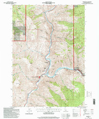 1995 Riggins1999 Print · USGSRiggins and the river canyon country are shown here in the mid-1990s as the town remains centered around the confluence of the Salmon and Little Salmon. Researchers can locate local landmarks like the North Riggins Cemetery, Salmon River High School, and the Idaho State Emergency Airstrip.
End of results
Showing maps 1-7 of 7
Frequently asked questions
- What are the different types of historical maps available for Riggins?
- What is the oldest map of Riggins?
- Where can I purchase historical maps of Riggins for my home or office?
- Where can I download high-res historical maps of Riggins?
- Are there historical topographic maps available for Riggins?
- Is there historical aerial imagery available for Riggins?
- Where are historical maps of Riggins sourced from?