1940s Maps of Teton County, Idaho
Explore 4 historic maps of Teton County from the 1940s. These maps offer a rare glimpse into what life looked like during the 1940s — showing old roads, neighborhoods, homes, and landmarks that have changed or disappeared over time.
Whether you're researching your family's past, planning a metal detecting trip, or studying how Teton County's landscape evolved across the 1940s, these high-resolution maps are a powerful tool for exploring the history of this region.
- Focus on a specific era: All maps on this page are from the 1940s, giving you a focused view of this time period.
- See what’s changed: Compare century-old streets, trails, and buildings to today's modern landscape using overlays and satellite layers.
- Research with precision: Use these maps for genealogy, historical research, land use analysis, or educational projects.
- View, download, or print: Maps are fully viewable online in high resolution, and can be downloaded or printed for your own records.
Start exploring Teton County's history through authentic maps from the 1940s. This is your window into the past.
Teton County, ID maps
(4)- 1943 Map of Driggs, 1955 Print
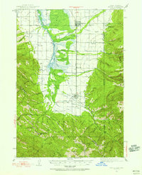 1943 Driggs1955 Print · USGSTeton Valley during the mid-forties is depicted as a thriving agricultural and rail corridor between the high peaks of the Teton Mountains. Researchers can trace the heritage of local rural life through labels for Bates Sch, Darby Ch, and the Union Pacific line.3 unique versions available
 - 1943 Map of Garns Mtn, 1957 Print
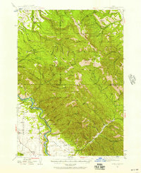 1943 Garns Mtn1957 Print · USGSEastern Idaho's high ridges and the winding Snake River corridor are captured here during the mid-1940s. Researchers can locate remote industrial sites like the Brown Bear Mine, early education landmarks such as the Upper Pine Creek Sch, and the Durrant Ranch.3 unique versions available
 - 1946 Map of Driggs
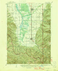 1946 Driggs1946 Print · USGSThe Teton Valley was a landscape of remote mountain peaks and irrigated ranch land during the mid-forties. Genealogists and historians can trace old homestead sites near Bates Sch and Sorensen or follow the historic Union Pacific rail line between Driggs and Victor.
 - 1946 Map of Garns Mtn
 1946 Garns Mtn1946 Print · USGSHigh-country ranching and coal mining define this Idaho landscape in the 1940s, situated where the Snake River meets the Big Flat. Genealogists and historians can trace family locations at the Durant Ranch or follow the local mining economy through sites like the Mikesell Mine and Pintar Mine.
End of results
Showing maps 1-4 of 4
Top cities of Teton County
Frequently asked questions
- What are the different types of historical maps available for Teton County?
- What is the oldest map of Teton County?
- Where can I purchase historical maps of Teton County for my home or office?
- Where can I download high-res historical maps of Teton County?
- Are there historical topographic maps available for Teton County?
- Is there historical aerial imagery available for Teton County?
- Where are historical maps of Teton County sourced from?