1970s Maps of Teton County, Idaho
Explore 7 historic maps of Teton County from the 1970s. These maps offer a rare glimpse into what life looked like during the 1970s — showing old roads, neighborhoods, homes, and landmarks that have changed or disappeared over time.
Whether you're researching your family's past, planning a metal detecting trip, or studying how Teton County's landscape evolved across the 1970s, these high-resolution maps are a powerful tool for exploring the history of this region.
- Focus on a specific era: All maps on this page are from the 1970s, giving you a focused view of this time period.
- See what’s changed: Compare century-old streets, trails, and buildings to today's modern landscape using overlays and satellite layers.
- Research with precision: Use these maps for genealogy, historical research, land use analysis, or educational projects.
- View, download, or print: Maps are fully viewable online in high resolution, and can be downloaded or printed for your own records.
Start exploring Teton County's history through authentic maps from the 1970s. This is your window into the past.
Teton County, ID maps
(7)- 1977 Map of Stouts Mtn, 1978 Print
 1977 Stouts Mtn1978 Print · USGSThe high backcountry of Bonneville County is captured in the late seventies, showing a landscape defined by forest service management and early recreational development. Researchers can trace historic access routes like the Pack Trails and locate family-named landmarks including Roy Farnes Spring and Mike Spencer Canyon.2 unique versions available
 - 1978 Map of Driggs
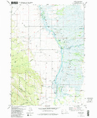
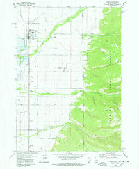 1978 Driggs1978 Print · USGSThe Teton Basin comes alive in the late seventies as a hub of rail, ranching, and mountain access. Genealogists and historians can trace the Union Pacific line through Driggs, find the Driggs-Darby Cem, or locate the old Drive-in Theater.2 unique versions available
 - 1978 Map of Fourth of July Peak
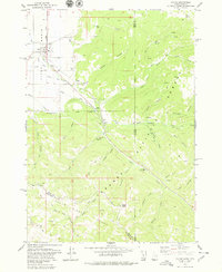
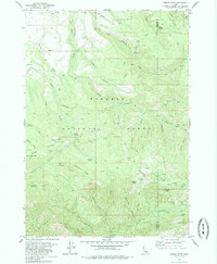
 1978 Fourth of July Peak1978 Print · USGSThe high peaks and irrigation networks of Teton County are captured in the late 1970s as the wilderness meets the basin. Local historians and hikers can trace remote landmarks like Walton Mine and Fourth of July Peak or the path of the Spencer Canal.2 unique versions available
 - 1978 Map of Garns Mtn
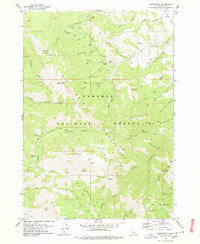 1978 Garns Mtn1978 Print · USGSThe mining landscape of the Big Hole Mountains is preserved here during the late 1970s. You can trace the rugged network of pack trails connecting the Packsaddle Mine, Hillman Mine, and Idaho Mine across the high ridges.2 unique versions available
 - 1978 Map of Victor, 1979 Print
 1978 Victor1979 Print · USGSVictor and the southern Teton Basin are shown in the late seventies as the rail lines met the mountains. Genealogists and hikers can trace the Victor Cem, follow the Union Pacific tracks, or explore the Trail Creek Trail and Mike Harris Creek.3 unique versions available
 - 1979 Map of Bates, 1985 Print
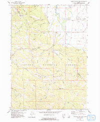
 1979 Bates1985 Print · USGSTeton County in the late 1970s is characterized by the winding Teton River and the high ridges of the Targhee National Forest. Researchers can trace old family sites near Bates, locate the Cedron Cem, or follow the Long Ridge Trail into the mountains.2 unique versions available
 - 1979 Map of Temple Peak, 1985 Print
 1979 Temple Peak1985 Print · USGSThe high country of the Madison and Teton county line is captured in the late seventies, showing a landscape defined by forest service trails and remote camps. Genealogists and historians can trace the paths to Browning, a Mine in Coalmine Canyon, and the waters of Spring Castle Lake.
End of results
Showing maps 1-7 of 7
Top cities of Teton County
Frequently asked questions
- What are the different types of historical maps available for Teton County?
- What is the oldest map of Teton County?
- Where can I purchase historical maps of Teton County for my home or office?
- Where can I download high-res historical maps of Teton County?
- Are there historical topographic maps available for Teton County?
- Is there historical aerial imagery available for Teton County?
- Where are historical maps of Teton County sourced from?