1900s (20th Century) Maps of Yellow Pine, Idaho
Explore 8 historic maps of Yellow Pine from the 1900s (20th Century). These maps offer a rare glimpse into what life looked like during the 1900s — showing old roads, neighborhoods, homes, and landmarks that have changed or disappeared over time.
Whether you're researching your family's past, planning a metal detecting trip, or studying how Yellow Pine's landscape evolved across the 1900s, these high-resolution maps are a powerful tool for exploring the history of this region.
- Focus on a specific era: All maps on this page are from the 1900s, giving you a focused view of this time period.
- See what’s changed: Compare century-old streets, trails, and buildings to today's modern landscape using overlays and satellite layers.
- Research with precision: Use these maps for genealogy, historical research, land use analysis, or educational projects.
- View, download, or print: Maps are fully viewable online in high resolution, and can be downloaded or printed for your own records.
Start exploring Yellow Pine's history through authentic maps from the 1900s. This is your window into the past.
Yellow Pine, ID maps
(8)- 1937 Map of Yellow Pine
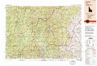
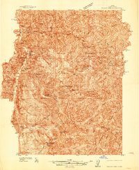 1937 Yellow Pine1937 Print · USGSMining and forest management in central Idaho were in full swing during the late 1930s as this survey of the Payette National Forest was completed. Researchers can trace the layout of the Stibnite mining camp, locate the Johnston Creek Ranger Sta, and identify high-altitude outposts like the Meadow Creek Lookout.
 - 1943 Map of Yellow Pine
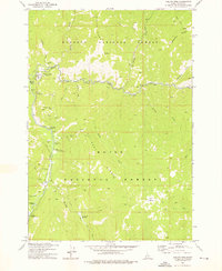
 1943 Yellow Pine1943 Print · USGSThe Yellow Pine backcountry during the 1930s is revealed as a center for remote mining and forest service operations. Researchers can trace early aviation and industry through sites like Oberbilling Airport, the Stibnite outpost, and the Antimony Mine.2 unique versions available
 - 1957 Map of Challis, 1964 Print
 1957 Challis1964 Print · USGSCentral Idaho in the late fifties and early sixties remains a territory of remote mining camps and high-mountain ranger stations. Trace historic mining operations like the Lucky Boy Mine or locate isolated homesteads including Robinson Bar Ranch and Allison Ranch.3 unique versions available
 - 1960 Map of Challis
 1960 Challis1960 Print · USGSCentral Idaho’s high backcountry is detailed here in the early sixties, showing the remote ranching and mining life across five national forests. Genealogists and researchers can trace family holdings at the Silva Ranch or Jones Ranch and find historic sites like Redfish Lake Lodge and Clayton.
 - 1963 Map of Challis
 1963 Challis1963 Print · USGSCentral Idaho's mountain corridors and mining districts appear in detail during the early sixties, highlighting the remote settlements of Challis and Stanley. Researchers can trace the legacy of the gold and silver rushes through labels for Bonanza, the Bayhorse Mine, and the Falconberry ranch.
 - 1973 Map of Yellow Pine, 1976 Print
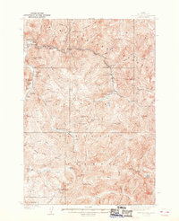
 1973 Yellow Pine1976 Print · USGSIn the Idaho backcountry during the 1970s, this area shows a landscape defined by forest service outposts and remote mountain ranches. You can trace early settlement and infrastructure through Pioneer Cem, the Abstein Place, and the Johnson Creek Airport.2 unique versions available
 - 1982 Map of Pistol Creek
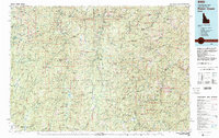 1982 Pistol Creek1982 Print · USGSThe central Idaho wilderness in the early eighties was a landscape of remote mining camps and backcountry airfields. Researchers can trace the history of mineral extraction at the Thunder Mountain Mine or locate early aviation sites like the Stibnite Landing Strip and Landmark Landing Strip.
 - 1989 Map of Challis
 1989 Challis1989 Print · USGSCentral Idaho in the late eighties remains a vast expanse of protected wilderness and high-mountain drainages. Researchers can trace remote settlements and backcountry outposts like Custer, Stibnite, and Sunbeam along the Salmon River and its many forks.2 unique versions available
End of results
Showing maps 1-8 of 8
Frequently asked questions
- What are the different types of historical maps available for Yellow Pine?
- What is the oldest map of Yellow Pine?
- Where can I purchase historical maps of Yellow Pine for my home or office?
- Where can I download high-res historical maps of Yellow Pine?
- Are there historical topographic maps available for Yellow Pine?
- Is there historical aerial imagery available for Yellow Pine?
- Where are historical maps of Yellow Pine sourced from?