2000-2009 Maps of Washington County, Idaho
Explore 11 historic maps of Washington County from 2000-2009. These maps offer a rare glimpse into what life looked like during the 2000s — showing old roads, neighborhoods, homes, and landmarks that have changed or disappeared over time.
Whether you're researching your family's past, planning a metal detecting trip, or studying how Washington County's landscape evolved across the 2000s, these high-resolution maps are a powerful tool for exploring the history of this region.
- Focus on a specific era: All maps on this page are from the 2000s, giving you a focused view of this time period.
- See what’s changed: Compare century-old streets, trails, and buildings to today's modern landscape using overlays and satellite layers.
- Research with precision: Use these maps for genealogy, historical research, land use analysis, or educational projects.
- View, download, or print: Maps are fully viewable online in high resolution, and can be downloaded or printed for your own records.
Start exploring Washington County's history through authentic maps from the 2000s. This is your window into the past.
Washington County, ID maps
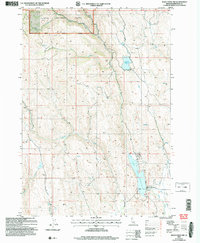
(11)- 2004 Map of Rush Peak, 2007 Print
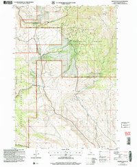
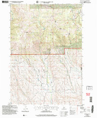 2004 Rush Peak2007 Print · USGSThe high country of the Cuddy Mountains in the early 2000s offers a look at the timber and watershed geography of the Payette National Forest. Researchers can trace the boundaries of the Council Weiser Ranger District and locate landmarks like Rush Falls and Goodrich.
 - 2004 Map of Cuddy Mountain, 2007 Print
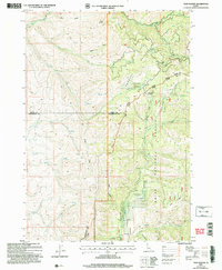
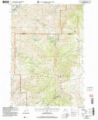 2004 Cuddy Mountain2007 Print · USGSThe high Idaho backcountry of the Payette National Forest is captured here in the early 2000s, where the Adams and Washington county lines meet. Researchers can trace historical mining efforts through numerous labeled prospects, Adits, and high-country landmarks like Rush Peak and Lost Basin.
 - 2004 Map of Crooked River Point, 2007 Print
 2004 Crooked River Point2007 Print · USGSThe high ridges of the Cuddy Mountains appear here in the early 2000s, showing a landscape defined by timber, water, and mining. Genealogists and historians can trace legacy mining sites including several Mine Shafts, an Adit, and the Hornet Interpretive Site.
 - 2004 Map of Sturgill Peak, 2007 Print
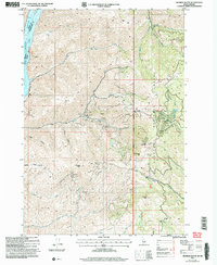
 2004 Sturgill Peak2007 Print · USGSThe high Hitt Mountains of Washington County come into focus in the early 2000s, showing a landscape of forest management and mining. Researchers can trace the drainage of Mann Creek or locate landmarks like the Open Pit Mine and the summit of Sturgill Peak.
 - 2004 Map of Mann Creek NW, 2007 Print
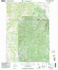
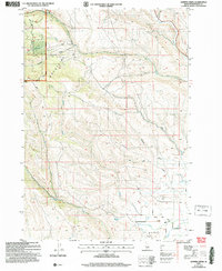
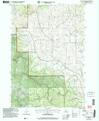
 2004 Mann Creek NW2007 Print · USGSWashington County, Idaho, at the turn of the millennium shows a landscape shaped by water management and forest service activity. Researchers can trace the layout of the Mann Creek Dam, the Fairchild Reservoir, and extraction sites like the Gravel Pit.
 - 2004 Map of Twin Sisters, 2007 Print
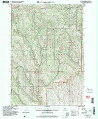
 2004 Twin Sisters2007 Print · USGSThe high timber and headwaters of the central Idaho mountains are mapped here just after the turn of the millennium. Researchers can trace the county lines and forest boundaries between Twin Sisters, the Middle Fork Weiser River, and Lava Ridge.
 - 2004 Map of Monroe Butte, 2007 Print
 2004 Monroe Butte2007 Print · USGSThe Hitt Mountains and Payette National Forest define this Idaho-Oregon border region as it appeared in the early 2000s. Researchers can trace historical mining activity at the Mortimer Mine or explore high-altitude landmarks like Chinamans Hat and Monroe Butte.
 - 2004 Map of Hopper Creek, 2007 Print
 2004 Hopper Creek2007 Print · USGSThe Idaho-Washington borderlands are captured here in the early 2000s, showing the high-elevation terrain of the Payette National Forest. Researchers can trace old family landmarks and water rights at Looney Spring, the local Cem, and ranching sites in Shoe Peg Valley.
 - 2004 Map of Advent Gulch, 2007 Print
 2004 Advent Gulch2007 Print · USGSThe Cuddy Mountains and Fox Prairie are surveyed here during the mid-2000s, showing a rugged Idaho landscape managed for forestry and minerals. Researchers can trace numerous Prospects and Adits among the headwaters of Advent Gulch and Brownlee Creek.
 - 2004 Map of Goodrich, 2007 Print
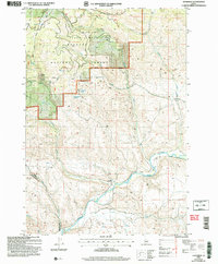 2004 Goodrich2007 Print · USGSThe Weiser River valley near the Adams and Washington county line is captured here in the early 2000s. Researchers can trace the rural road networks around Goodrich, locate Bacon, and find backcountry water sources like Homestead Spring and Strawberry Spring.
 - 2004 Map of Peck Mountain, 2007 Print
 2004 Peck Mountain2007 Print · USGSIn the early twenty-first century, this Adams County landscape shows the intersection of the Payette National Forest and local ranching and mining history. Genealogists and researchers can trace family-named landmarks and historical sites like Peck Mountain, the Cem on Hornet Creek, and a local Prospect.
End of results
Showing maps 1-11 of 11
Top cities of Washington County
Frequently asked questions
- What are the different types of historical maps available for Washington County?
- What is the oldest map of Washington County?
- Where can I purchase historical maps of Washington County for my home or office?
- Where can I download high-res historical maps of Washington County?
- Are there historical topographic maps available for Washington County?
- Is there historical aerial imagery available for Washington County?
- Where are historical maps of Washington County sourced from?