1990s Maps of Tamms, Illinois
Explore 2 historic maps of Tamms from the 1990s. These maps offer a rare glimpse into what life looked like during the 1990s — showing old roads, neighborhoods, homes, and landmarks that have changed or disappeared over time.
Whether you're researching your family's past, planning a metal detecting trip, or studying how Tamms's landscape evolved across the 1990s, these high-resolution maps are a powerful tool for exploring the history of this region.
- Focus on a specific era: All maps on this page are from the 1990s, giving you a focused view of this time period.
- See what’s changed: Compare century-old streets, trails, and buildings to today's modern landscape using overlays and satellite layers.
- Research with precision: Use these maps for genealogy, historical research, land use analysis, or educational projects.
- View, download, or print: Maps are fully viewable online in high resolution, and can be downloaded or printed for your own records.
Start exploring Tamms's history through authentic maps from the 1990s. This is your window into the past.
Tamms, IL maps
(2)- 1996 Map of Mill Creek, 1998 Print
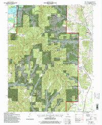 1996 Mill Creek1998 Print · USGSSouthern Illinois at the end of the twentieth century reveals a landscape defined by the deep woods of the Shawnee National Forest and the Southern Pacific rail line. Researchers can locate local landmarks like Mill Creek, McClure Cem, and the old Lingle Sch.
 - 1996 Map of Tamms, 1998 Print
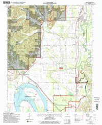 1996 Tamms1998 Print · USGSIn the mid-nineties, the Alexander County bottomlands were a mosaic of state conservation lands and timbered national forest. Researchers can trace family history through sites like Richwood Cem and old rail points such as Davey Switch or Unity.2 unique versions available
End of results
Showing maps 1-2 of 2
Top cities near Tamms
- Cape Girardeau historical maps
- Anna historical maps
- Scott City historical maps
- Cairo historical maps
- Jonesboro historical maps
- Mounds historical maps
See more
Frequently asked questions
- What are the different types of historical maps available for Tamms?
- What is the oldest map of Tamms?
- Where can I purchase historical maps of Tamms for my home or office?
- Where can I download high-res historical maps of Tamms?
- Are there historical topographic maps available for Tamms?
- Is there historical aerial imagery available for Tamms?
- Where are historical maps of Tamms sourced from?