1980s Maps of Mound Station, Illinois
Explore 4 historic maps of Mound Station from the 1980s. These maps offer a rare glimpse into what life looked like during the 1980s — showing old roads, neighborhoods, homes, and landmarks that have changed or disappeared over time.
Whether you're researching your family's past, planning a metal detecting trip, or studying how Mound Station's landscape evolved across the 1980s, these high-resolution maps are a powerful tool for exploring the history of this region.
- Focus on a specific era: All maps on this page are from the 1980s, giving you a focused view of this time period.
- See what’s changed: Compare century-old streets, trails, and buildings to today's modern landscape using overlays and satellite layers.
- Research with precision: Use these maps for genealogy, historical research, land use analysis, or educational projects.
- View, download, or print: Maps are fully viewable online in high resolution, and can be downloaded or printed for your own records.
Start exploring Mound Station's history through authentic maps from the 1980s. This is your window into the past.
Mound Station, IL maps
(4)- 1981 Map of Clayton
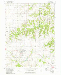 1981 Clayton1981 Print · USGSWestern Illinois farm country and the village of Clayton are captured here in the early eighties. Researchers can locate numerous family burial grounds including Knight Cem and Howe Cem, or trace the rail-era footprint of Timewell (Mound Station).
 - 1981 Map of Lake Mt. Sterling
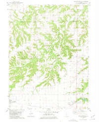 1981 Lake Mt. Sterling1981 Print · USGSWestern Illinois farm and timberlands are captured here in the early 1980s as rural life centered around small creek-side settlements. Researchers can locate numerous family burial sites like Sims Cem and trace the local impact of Lake Mt Sterling.
 - 1985 Map of Macomb
 1985 Macomb1985 Print · USGSWest Central Illinois in the mid-eighties shows a robust network of river towns and rail corridors spanning from the Illinois River to the Lamoine. Genealogists and historians can trace the foundations of Macomb, find rural landmarks like Pennington Point, or locate early conservation sites like Argyle Lake State Park.
 - 1989 Map of Macomb
 1989 Macomb1989 Print · USGSWest Central Illinois in the late eighties shows a landscape of river-bottom conservation and rail-town commerce. Researchers can trace the extensive wetlands of the Illinois River or locate historic transport hubs in Macomb, Colchester, and Beardstown.
End of results
Showing maps 1-4 of 4
Top cities near Mound Station
- Mount Sterling historical maps
- Camp Point historical maps
- Clayton historical maps
- Augusta historical maps
- Golden historical maps
- Versailles historical maps
See more
Top neighborhoods of Mound Station
Frequently asked questions
- What are the different types of historical maps available for Mound Station?
- What is the oldest map of Mound Station?
- Where can I purchase historical maps of Mound Station for my home or office?
- Where can I download high-res historical maps of Mound Station?
- Are there historical topographic maps available for Mound Station?
- Is there historical aerial imagery available for Mound Station?
- Where are historical maps of Mound Station sourced from?