1940s Maps of Christian County, Illinois
Explore 4 historic maps of Christian County from the 1940s. These maps offer a rare glimpse into what life looked like during the 1940s — showing old roads, neighborhoods, homes, and landmarks that have changed or disappeared over time.
Whether you're researching your family's past, planning a metal detecting trip, or studying how Christian County's landscape evolved across the 1940s, these high-resolution maps are a powerful tool for exploring the history of this region.
- Focus on a specific era: All maps on this page are from the 1940s, giving you a focused view of this time period.
- See what’s changed: Compare century-old streets, trails, and buildings to today's modern landscape using overlays and satellite layers.
- Research with precision: Use these maps for genealogy, historical research, land use analysis, or educational projects.
- View, download, or print: Maps are fully viewable online in high resolution, and can be downloaded or printed for your own records.
Start exploring Christian County's history through authentic maps from the 1940s. This is your window into the past.
Christian County, IL maps
(4)- 1946 Map of Nokomis, 1965 Print
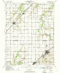 1946 Nokomis1965 Print · USGSThe Illinois prairie south of Taylorville reached its industrial and agricultural peak just after World War II. Genealogists can trace family names across dozens of rural sites, including Mound Chapel, D'Arcy Sch, and the mining corridor near Coalton.2 unique versions available
 - 1947 Map of Pana
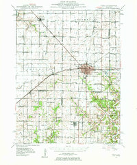 1947 Pana1947 Print · USGSRailroad lines from three major carriers converge at Pana in the mid-1940s, serving a productive agricultural landscape across three counties. Researchers can locate dozens of country schools and churches, including Swamp Angel School, Sacred Heart Cem, and Owaneco.
 - 1949 Map of Nokomis
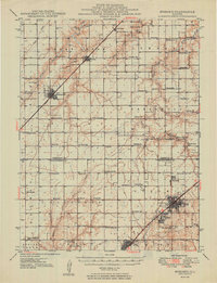 1949 Nokomis1949 Print · USGSCentral Illinois rail and agricultural life are captured here in the late 1940s, showing the intricate network of country schools and family cemeteries. Genealogists can locate family sites near St Maurice Cem or trace the many local schoolhouses like Mound Sch and Prosperity Sch.2 unique versions available
 - 1949 Map of Pana
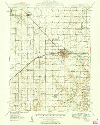 1949 Pana1949 Print · USGSCentral Illinois rail traffic peaked in the late 1940s as five major lines converged at the hub of Pana. Researchers can trace the rural school system and family burial grounds such as Durbin College Sch and Mound Cem.2 unique versions available
End of results
Showing maps 1-4 of 4
Top cities of Christian County
- Taylorville historical maps
- Kincaid historical maps
- Assumption historical maps
- Edinburg historical maps
- Morrisonville historical maps
- Stonington historical maps
See more
Frequently asked questions
- What are the different types of historical maps available for Christian County?
- What is the oldest map of Christian County?
- Where can I purchase historical maps of Christian County for my home or office?
- Where can I download high-res historical maps of Christian County?
- Are there historical topographic maps available for Christian County?
- Is there historical aerial imagery available for Christian County?
- Where are historical maps of Christian County sourced from?