1980s Maps of Christian County, Illinois
Explore 19 historic maps of Christian County from the 1980s. These maps offer a rare glimpse into what life looked like during the 1980s — showing old roads, neighborhoods, homes, and landmarks that have changed or disappeared over time.
Whether you're researching your family's past, planning a metal detecting trip, or studying how Christian County's landscape evolved across the 1980s, these high-resolution maps are a powerful tool for exploring the history of this region.
- Focus on a specific era: All maps on this page are from the 1980s, giving you a focused view of this time period.
- See what’s changed: Compare century-old streets, trails, and buildings to today's modern landscape using overlays and satellite layers.
- Research with precision: Use these maps for genealogy, historical research, land use analysis, or educational projects.
- View, download, or print: Maps are fully viewable online in high resolution, and can be downloaded or printed for your own records.
Start exploring Christian County's history through authentic maps from the 1980s. This is your window into the past.
Christian County, IL maps
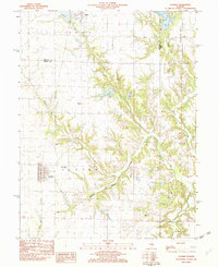
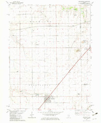
(19)- 1980 Map of Nokomis
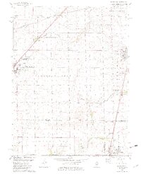
 1980 Nokomis1980 Print · USGSNokomis and the surrounding coal-belt townships are captured here during the late twentieth century, showing the region's industrial and rural character. Genealogists and local historians can trace family sites like St Louis Cem, Oak Grove Cem, and Center Grove Ch among the rail lines and creek forks.
 - 1980 Map of Morrisonville
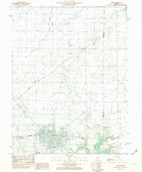
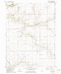
 1980 Morrisonville1980 Print · USGSMorrisonville and Palmer thrive along the Norfolk and Western railroad in the early 1980s. Local researchers can trace family roots at several rural burial sites, including St Maurice Cem, Durbin Cem, and Morrisonville Cem.2 unique versions available
 - 1980 Map of Nokomis SW
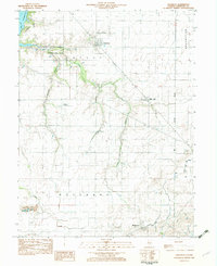
 1980 Nokomis SW1980 Print · USGSMontgomery County farmland is seen here in the late seventies as industrial and recreational infrastructure began to emerge. Researchers can trace the development of Lake Glenn Shoals and locate landmarks like Mt Zion Ch and the Hillsboro Gas Storage Area.
 - 1982 Map of Litchfield
 1982 Litchfield1982 Print · USGSThe coal and rail corridors of Central Illinois are captured here in the early eighties as the region balanced industrial mining with its agricultural roots. Researchers can trace family history through sites like Zelmer Memorial Cemetery or the grounds of Blackburn College and the Crown Mine No 1.
 - 1982 Map of Pana
 1982 Pana1982 Print · USGSThe rail-driven hub of Pana is captured here in the early eighties, showcasing its crossroads as a center for transport and local industry. Genealogists and historians can trace family plots at Linwood Cem or explore the layout of the Tri County Fairground and Kehias Park.
 - 1982 Map of Oconee
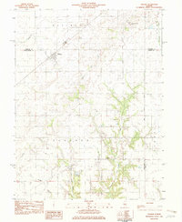
 1982 Oconee1982 Print · USGSShelby and Christian counties in the early eighties were still defined by traditional rail corridors and rural parishes. Genealogists can trace family landmarks like Oconee Mound Cem, Hopewell Ch, and the Illinois Central Gulf line.
 - 1982 Map of Owaneco
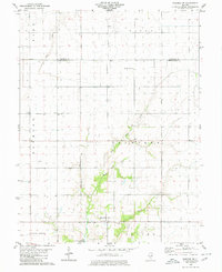
 1982 Owaneco1982 Print · USGSChristian County agricultural life in the early eighties is captured here, centered on the village of Owaneco. Genealogists can locate family sites at Durbin Cem or Buckeye Cem while tracing the Baltimore and Ohio rail lines.
 - 1982 Map of Ohlman
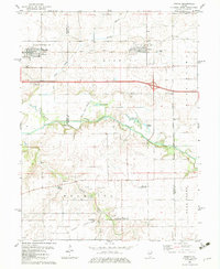
 1982 Ohlman1982 Print · USGSOhlman and the surrounding prairie were deeply established by the early 1980s, when the rail network still connected these Montgomery County communities. Researchers can trace land divisions along the Third Principal Meridian and locate local sites like Shiloh Ch and Ohlman Cem.
 - 1982 Map of Mechanicsburg, 1983 Print
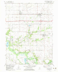 1982 Mechanicsburg1983 Print · USGSMechanicsburg and the surrounding Sangamon County prairie are shown in the early 1980s as a landscape of productive farms and active oil extraction. Genealogists and local historians can locate Mechanicsburg Cem, the ILLINOIS TERMINAL AND WESTERN rail line, and the Mechanicsburg Oil Field.
 - 1982 Map of Stonington, 1983 Print
 1982 Stonington1983 Print · USGSCentral Illinois agriculture and industry meet along the Christian-Macon county line in the early 1980s. Genealogists and local historians can trace the town of Stonington, locate Mt Zion Cem, and see the extent of the Mt Auburn Consolidated Oil Field.2 unique versions available
 - 1982 Map of Grove City, 1983 Print
 1982 Grove City1983 Print · USGSChristian County in the early eighties shows a productive landscape where traditional prairie farming meets active energy production. Researchers can locate family landmarks like Buckhart Cem and Liberty Mosquito Ch alongside the Baltimore and Ohio rail line.
 - 1982 Map of Kincaid, 1983 Print
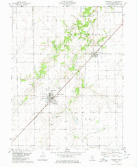
 1982 Kincaid1983 Print · USGSChristian County's coal and rail corridor is captured here in the early eighties, showcasing a cluster of industrial settlements. Genealogists and historians can trace family roots through Kincaid, Tovey, and Sicily, or locate landmarks like Bethany Cem and the Mine Shaft.
 - 1982 Map of Niantic, 1983 Print
 1982 Niantic1983 Print · USGSNiantic and Illiopolis sit at the heart of this early 1980s landscape, where the Sangamon River valley meets a bustling rail corridor. Researchers can locate generational sites like Hunter Cem, Long Point Ch, and the rural outpost of Osbernville.
 - 1982 Map of Taylorville, 1983 Print
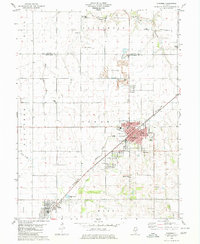
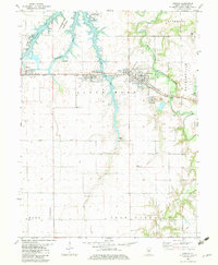
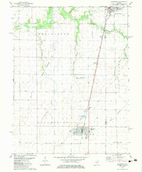
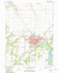 1982 Taylorville1983 Print · USGSTaylorville and its surrounding townships show a mature landscape of rail corridors and river confluences in the early eighties. Genealogists and local researchers can trace family landmarks like Oak Hill Cemetery, find the old Drive-in Theater, or locate the St. Vincent Hospital campus.
 - 1982 Map of Assumption, 1983 Print
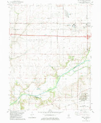
 1982 Assumption1983 Print · USGSChristian and Shelby Counties are shown here during the early eighties, where the regional rail economy and local energy production intersect. Genealogists and historians can locate St Marys Cem, trace the Illinois Central Gulf railroad, and find smaller sites like Seigfried and Hayes Cem.
 - 1982 Map of Mount Auburn, 1983 Print
 1982 Mount Auburn1983 Print · USGSAgricultural and industrial life meet along the Sangamon River during the early eighties. Genealogists and local historians can trace family plots at Riverside Cem or study the rail operations of the Norfolk and Western and Baltimore and Ohio.
 - 1982 Map of Edinburg, 1983 Print
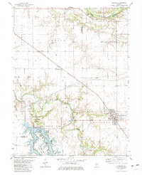 1982 Edinburg1983 Print · USGSChristian and Sangamon counties in the early eighties show a landscape where recreation at Sangchris Lake State Park meets active energy production. Researchers can trace family history through sites like Oak Hill Cem and the diagonal route of the Baltimore and Ohio railroad.
 - 1982 Map of Macon West, 1983 Print
 1982 Macon West1983 Print · USGSCentral Illinois farmlands in the early eighties show a landscape organized by rail corridors and quiet country churches. Genealogists can trace family plots at South Macon Cem, Adams Cem, or Traughber Cem and locate historic schools like the High Sch in Moweaqua.2 unique versions available
 - 1985 Map of Springfield
 1985 Springfield1985 Print · USGSCentral Illinois during the mid-eighties shows a landscape of growing state capital influence and deep historical roots. Genealogists and historians can trace family sites near Oak Ridge Cem or follow the path of the Sangamon River past Williamsville and Riverton.2 unique versions available
End of results
Showing maps 1-19 of 19
Top cities of Christian County
- Taylorville historical maps
- Kincaid historical maps
- Assumption historical maps
- Edinburg historical maps
- Morrisonville historical maps
- Stonington historical maps
See more
Frequently asked questions
- What are the different types of historical maps available for Christian County?
- What is the oldest map of Christian County?
- Where can I purchase historical maps of Christian County for my home or office?
- Where can I download high-res historical maps of Christian County?
- Are there historical topographic maps available for Christian County?
- Is there historical aerial imagery available for Christian County?
- Where are historical maps of Christian County sourced from?