1990s Maps of Christian County, Illinois
Explore 13 historic maps of Christian County from the 1990s. These maps offer a rare glimpse into what life looked like during the 1990s — showing old roads, neighborhoods, homes, and landmarks that have changed or disappeared over time.
Whether you're researching your family's past, planning a metal detecting trip, or studying how Christian County's landscape evolved across the 1990s, these high-resolution maps are a powerful tool for exploring the history of this region.
- Focus on a specific era: All maps on this page are from the 1990s, giving you a focused view of this time period.
- See what’s changed: Compare century-old streets, trails, and buildings to today's modern landscape using overlays and satellite layers.
- Research with precision: Use these maps for genealogy, historical research, land use analysis, or educational projects.
- View, download, or print: Maps are fully viewable online in high resolution, and can be downloaded or printed for your own records.
Start exploring Christian County's history through authentic maps from the 1990s. This is your window into the past.
Christian County, IL maps
(13)- 1998 Map of New City, 2000 Print
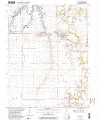
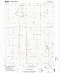
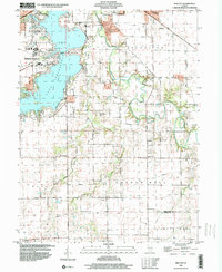 1998 New City2000 Print · USGSCentral Illinois during the late nineties shows a landscape of suburban growth and traditional farming. Genealogists can trace family names at Mottarville Cem or locate the rural crossroads of New City and Beamington near the Sangamon River.
 - 1998 Map of Morrisonville, 2002 Print
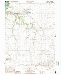
 1998 Morrisonville2002 Print · USGSChristian County's prairie landscapes and rail-aligned towns are preserved in this late-twentieth-century survey. Genealogists can locate several family and community burial grounds, including St Maurice Cem, Palmer Cem, and Durbin Cem.
 - 1998 Map of Nokomis, 2002 Print
 1998 Nokomis2002 Print · USGSThe Montgomery County prairie around the turn of the millennium shows a landscape defined by small-town grids and industrial sites. Family historians can trace local roots through landmarks like Oak Grove Cem, St Paul Sch, and the quiet settlements of Coalton and Witt.
 - 1998 Map of Nokomis SW, 2002 Print
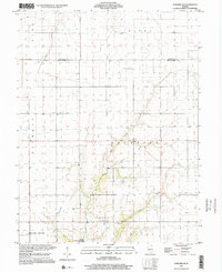 1998 Nokomis SW2002 Print · USGSMontgomery County’s rural townships are captured in the late 1990s as the landscape balances agricultural heritage with modern infrastructure. Researchers can locate Mt Zion Ch, trace the banks of Lake Glenn Shoals, and identify the Hillsboro Gas Storage Area.
 - 1998 Map of Pana, 2002 Print
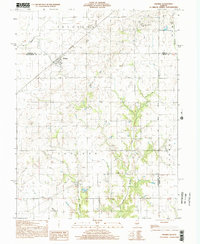
 1998 Pana2002 Print · USGSChristian and Shelby Counties come together at the turn of the millennium in this detailed study of the area. Researchers can trace family sites at Mound Cem, locate the Tri County Fairground, or follow the Main Drainage Ditch through the prairie.
 - 1998 Map of Kincaid, 2002 Print
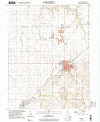
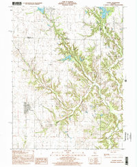
 1998 Kincaid2002 Print · USGSCoal and rail define this Christian County landscape in the late nineties as it transitions from heavy industry to lakeside recreation. Trace family roots and vanished infrastructure through Bulpitt, Bethany Cem, and the Mine Shaft near Jeisyville.
 - 1998 Map of Owaneco, 2002 Print
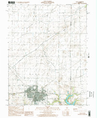
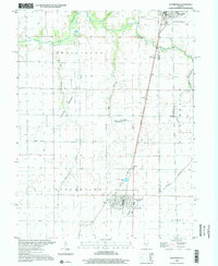
 1998 Owaneco2002 Print · USGSChristian County at the turn of the millennium shows a landscape of established rail towns and quiet rural townships. Genealogists and local historians can trace family roots through sites like Durbin Cem, the village of Owaneco, and the Baltimore and Ohio rail line.
 - 1998 Map of Assumption, 2002 Print
 1998 Assumption2002 Print · USGSChristian and Shelby Counties show a balanced landscape of agriculture and transit in the late 1990s. Researchers can trace the Consolidated Rail Corporation line as it connects Moweaqua, Radford, and Assumption, or locate family sites like St Marys Cem.
 - 1998 Map of Raymond, 2002 Print
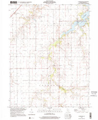
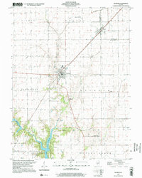 1998 Raymond2002 Print · USGSCentral Illinois farmland near the turn of the millennium is anchored by the rail towns of Raymond and Harvel. Researchers can trace rural cemetery locations like St Raymond Cem and explore the northern waters of Lou Yaeger Lake.
 - 1998 Map of Raymond NE, 2002 Print
 1998 Raymond NE2002 Print · USGSThe Montgomery and Christian County line serves as the anchor for this late-century look at the Illinois prairie. Researchers can trace the rural landscape across Bois D' Arc and Harvel townships, locating features like the Seitz Landing Strip and Horse Creek.
 - 1998 Map of Oconee, 2002 Print
 1998 Oconee2002 Print · USGSThe rural border of Christian and Shelby counties comes into focus in the late nineties, showing a landscape shaped by prairie farming and deep creek valleys. Researchers can trace the village of Oconee, locate the Sacred Heart Cem, or find the Oconee Mound Cem.
 - 1998 Map of Ohlman, 2002 Print
 1998 Ohlman2002 Print · USGSCentral Illinois farmland near the turn of the millennium is meticulously documented here across the borders of Montgomery, Christian, and Shelby counties. Researchers can trace rural lineages through Ohlman Cem, Shiloh Ch, and the settlement at Bailey.
 - 1998 Map of Clarksdale, 2002 Print
 1998 Clarksdale2002 Print · USGSAgricultural Christian County enters the late nineties as the waters of Lake Taylorville reshape the eastern landscape. Trace family roots at Anderson Cem and Vanderville or locate rural hubs like Providence Ch.
End of results
Showing maps 1-13 of 13
Top cities of Christian County
- Taylorville historical maps
- Kincaid historical maps
- Assumption historical maps
- Edinburg historical maps
- Morrisonville historical maps
- Stonington historical maps
See more
Frequently asked questions
- What are the different types of historical maps available for Christian County?
- What is the oldest map of Christian County?
- Where can I purchase historical maps of Christian County for my home or office?
- Where can I download high-res historical maps of Christian County?
- Are there historical topographic maps available for Christian County?
- Is there historical aerial imagery available for Christian County?
- Where are historical maps of Christian County sourced from?