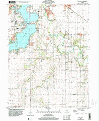
1998 Map of New City
USGS Topo · Published 2000About this map
Lake Springfield dominates the northwestern corner of this quadrangle, its shoreline serving as a recreational and educational hub for the region at the close of the 20th century. Along its banks, Sangamon State University and Lincoln Greens Golf Course mark the suburban reach of Springfield, while the Lindsay Bridge provides a vital connection across the water. The landscape transitions quickly from these developed areas into the agricultural heart of Sangamon County, where the Sangamon River and its South Fork meander through the terrain. Small settlements and rural junctions like New City and Beamington reflect a persistent 19th-century settlement pattern, anchored by numerous family and community burial grounds including Mottarville Cem, Brunk Cem, and Zion Cem. This 1998 snapshot captures the intersection of expanding university life and the steady, enduring presence of Illinois prairie farming communities.
Find a feature on this map
37 named features on this map. Tap any name to fly to it.
Don’t see what you’re looking for? This feature index may not catch every label — zoom into the map to look around manually.
Map Details
Editions of this 1998 New City Map
This is the sole edition of this map. No revisions or reprints were ever made.
Other maps of this area

1907 · Springfield
USGS Topo · 1:62,500

1922 · Divernon
USGS Topo · 1:62,500

1923 · Taylorville
USGS Topo · 1:62,500

1924 · Divernon
USGS Topo · 1:62,500

1925 · Taylorville
USGS Topo · 1:62,500

1930 · Springfield
USGS Topo · 1:62,500

1940 · Springfield
USGS Topo · 1:62,500

1950 · Springfield West
USGS Topo · 1:24,000

1950 · Springfield East
USGS Topo · 1:24,000

1954 · Mechanicsburg
USGS Topo · 1:62,500