1940s Maps of Martinsville, Illinois
Explore 2 historic maps of Martinsville from the 1940s. These maps offer a rare glimpse into what life looked like during the 1940s — showing old roads, neighborhoods, homes, and landmarks that have changed or disappeared over time.
Whether you're researching your family's past, planning a metal detecting trip, or studying how Martinsville's landscape evolved across the 1940s, these high-resolution maps are a powerful tool for exploring the history of this region.
- Focus on a specific era: All maps on this page are from the 1940s, giving you a focused view of this time period.
- See what’s changed: Compare century-old streets, trails, and buildings to today's modern landscape using overlays and satellite layers.
- Research with precision: Use these maps for genealogy, historical research, land use analysis, or educational projects.
- View, download, or print: Maps are fully viewable online in high resolution, and can be downloaded or printed for your own records.
Start exploring Martinsville's history through authentic maps from the 1940s. This is your window into the past.
Martinsville, IL maps
(2)- 1942 Map of Casey, 1965 Print
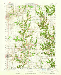 1942 Casey1965 Print · USGSEast-central Illinois comes to life in this mid-century survey of the rail and road networks connecting Casey and Martinsville. Genealogists can trace family legacies through numerous landmarks like Enlow Cem, Willis Chapel, and School No 3.2 unique versions available
 - 1943 Map of Casey
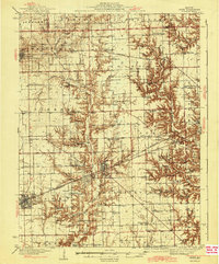 1943 Casey1943 Print · USGSEastern Illinois during the late thirties and early forties reveals a landscape of railroad towns and emerging oil infrastructure. Genealogists and researchers can trace dozens of rural landmarks, from the Abraham Lincoln Sch to the industrial TANK FARM and the Airway Beacon near Martinsville.2 unique versions available
End of results
Showing maps 1-2 of 2
Top cities near Martinsville
- Casey historical maps
- Marshall historical maps
- Hutton historical maps
- Kansas historical maps
- Ashmore historical maps
- Westfield historical maps
See more
Frequently asked questions
- What are the different types of historical maps available for Martinsville?
- What is the oldest map of Martinsville?
- Where can I purchase historical maps of Martinsville for my home or office?
- Where can I download high-res historical maps of Martinsville?
- Are there historical topographic maps available for Martinsville?
- Is there historical aerial imagery available for Martinsville?
- Where are historical maps of Martinsville sourced from?