1990s Maps of Martinsville, Illinois
Explore 2 historic maps of Martinsville from the 1990s. These maps offer a rare glimpse into what life looked like during the 1990s — showing old roads, neighborhoods, homes, and landmarks that have changed or disappeared over time.
Whether you're researching your family's past, planning a metal detecting trip, or studying how Martinsville's landscape evolved across the 1990s, these high-resolution maps are a powerful tool for exploring the history of this region.
- Focus on a specific era: All maps on this page are from the 1990s, giving you a focused view of this time period.
- See what’s changed: Compare century-old streets, trails, and buildings to today's modern landscape using overlays and satellite layers.
- Research with precision: Use these maps for genealogy, historical research, land use analysis, or educational projects.
- View, download, or print: Maps are fully viewable online in high resolution, and can be downloaded or printed for your own records.
Start exploring Martinsville's history through authentic maps from the 1990s. This is your window into the past.
Martinsville, IL maps
(2)- 1998 Map of Casey, 2002 Print
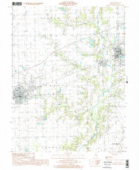 1998 Casey2002 Print · USGSClark County at the close of the twentieth century shows the agricultural heartland around Casey and Martinsville. Genealogists and historians can trace family lands across Parker and Orange townships or locate industrial landmarks like the Quarry.
 - 1998 Map of Clark Center, 2002 Print
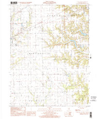 1998 Clark Center2002 Print · USGSThe rural landscape of Clark County at the close of the millennium reveals a quiet network of townships and timbered creek bottoms. Genealogists and local researchers can trace the vicinity of Clark Center, find a remote Cem, and follow the winding courses of Mill Creek or Joes Fork.
End of results
Showing maps 1-2 of 2
Top cities near Martinsville
- Casey historical maps
- Marshall historical maps
- Hutton historical maps
- Kansas historical maps
- Ashmore historical maps
- Westfield historical maps
See more
Frequently asked questions
- What are the different types of historical maps available for Martinsville?
- What is the oldest map of Martinsville?
- Where can I purchase historical maps of Martinsville for my home or office?
- Where can I download high-res historical maps of Martinsville?
- Are there historical topographic maps available for Martinsville?
- Is there historical aerial imagery available for Martinsville?
- Where are historical maps of Martinsville sourced from?