1980s Maps of Clay County, Illinois
Explore 9 historic maps of Clay County from the 1980s. These maps offer a rare glimpse into what life looked like during the 1980s — showing old roads, neighborhoods, homes, and landmarks that have changed or disappeared over time.
Whether you're researching your family's past, planning a metal detecting trip, or studying how Clay County's landscape evolved across the 1980s, these high-resolution maps are a powerful tool for exploring the history of this region.
- Focus on a specific era: All maps on this page are from the 1980s, giving you a focused view of this time period.
- See what’s changed: Compare century-old streets, trails, and buildings to today's modern landscape using overlays and satellite layers.
- Research with precision: Use these maps for genealogy, historical research, land use analysis, or educational projects.
- View, download, or print: Maps are fully viewable online in high resolution, and can be downloaded or printed for your own records.
Start exploring Clay County's history through authentic maps from the 1980s. This is your window into the past.
Clay County, IL maps
(9)- 1985 Map of Latona
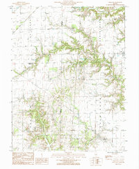
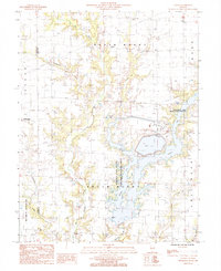 1985 Latona1985 Print · USGSJasper County in the 1980s shows a unique mix of heavy energy infrastructure and dedicated wildlife conservation. Researchers can trace the development of Newton Lake near the Power Plant and locate rural hubs like Latona and Winterrowd.
 - 1985 Map of Sailor Springs
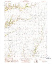
 1985 Sailor Springs1985 Print · USGSThe rural borderlands of Clay and Jasper counties are captured here in the mid-1980s, centered on the village of Sailor Springs. Genealogists and local historians can trace the creek-side settlements of Ingraham and Wendelin or locate family plots near Big Muddy Creek.
 - 1985 Map of Hord
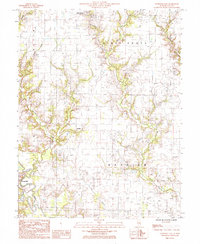
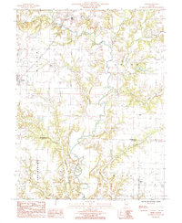 1985 Hord1985 Print · USGSEffingham and Clay counties in the mid-1980s reveal a landscape dominated by the winding Little Wabash River. Researchers can trace old family sites and rural settlements from Mason to Hord, or locate landmarks like Sublett Cem and Hill.
 - 1985 Map of Louisville West
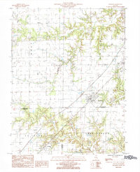
 1985 Louisville West1985 Print · USGSClay County in the mid-1980s reveals a prairie landscape structured by the Little Wabash River and its many creek systems. Genealogists and historians can trace the bounds of Louisville and Riffle alongside local landmarks like a Quarry and numerous rural Cemeteries.
 - 1985 Map of Oskaloosa
 1985 Oskaloosa1985 Print · USGSClay County and the surrounding countryside appear in detail during the mid-1980s, showcasing the rural road networks and township divisions. Local researchers can trace family lands near Iola and the winding banks of Skillet Fork or Dismal Creek.
 - 1985 Map of Eberle
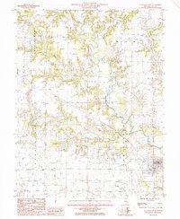
 1985 Eberle1985 Print · USGSSouthern Effingham and northern Clay counties appear here in the mid-1980s as the local oil industry and small crossroads settlements remained central to the landscape. Researchers can trace rural cemeteries and energy infrastructure near Eberle, Bible Grove, and the southern Oil Field.
 - 1985 Map of Louisville East
 1985 Louisville East1985 Print · USGSClay County at the dawn of the eighties shows a landscape of river-bottom farms and emerging energy infrastructure. Researchers can trace the banks of the Wabash River and locate rural sites like Bible Grove, the Hoosier locality, and a hilltop Cem.
 - 1985 Map of Edgewood
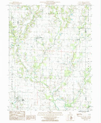
 1985 Edgewood1985 Print · USGSThe prairie of Effingham and Clay counties is captured here in the mid-eighties, centered on the rail-oriented town of Edgewood. Genealogists and local historians can trace the rail corridor through Mason and La Clede or find family land near Fulfer Creek.
 - 1986 Map of Olney
 1986 Olney1986 Print · USGSSouth-central Illinois in the mid-eighties shows a landscape of small agricultural towns linked by historic rail lines and prairie preserves. Trace family roots and vanished rail stops near Kinmundy, the Prairie Chicken Sanctuary, and Salem.2 unique versions available
End of results
Showing maps 1-9 of 9
Top cities of Clay County
- Flora historical maps
- Bible Grove historical maps
- Oskaloosa historical maps
- Sailor Springs historical maps
- Iola historical maps
Frequently asked questions
- What are the different types of historical maps available for Clay County?
- What is the oldest map of Clay County?
- Where can I purchase historical maps of Clay County for my home or office?
- Where can I download high-res historical maps of Clay County?
- Are there historical topographic maps available for Clay County?
- Is there historical aerial imagery available for Clay County?
- Where are historical maps of Clay County sourced from?