1950s Maps of Bloom Township, Illinois
Explore 6 historic maps of Bloom Township from the 1950s. These maps offer a rare glimpse into what life looked like during the 1950s — showing old roads, neighborhoods, homes, and landmarks that have changed or disappeared over time.
Whether you're researching your family's past, planning a metal detecting trip, or studying how Bloom Township's landscape evolved across the 1950s, these high-resolution maps are a powerful tool for exploring the history of this region.
- Focus on a specific era: All maps on this page are from the 1950s, giving you a focused view of this time period.
- See what’s changed: Compare century-old streets, trails, and buildings to today's modern landscape using overlays and satellite layers.
- Research with precision: Use these maps for genealogy, historical research, land use analysis, or educational projects.
- View, download, or print: Maps are fully viewable online in high resolution, and can be downloaded or printed for your own records.
Start exploring Bloom Township's history through authentic maps from the 1950s. This is your window into the past.
Bloom Township, IL maps
(6)- 1953 Map of Steger, 1955 Print
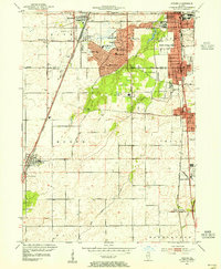 1953 Steger1955 Print · USGSSouthern Cook and Will Counties are shown in the early fifties as new suburban developments began to reshape the prairie landscape. Genealogists can trace family roots through numerous local landmarks, including Lincoln Fields Sta, Adams Cem, and the Sauk Trail Sch.4 unique versions available
 - 1953 Map of Calumet City, 1955 Print
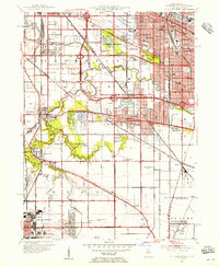 1953 Calumet City1955 Print · USGSThe Calumet region during the early fifties shows a burgeoning industrial and suburban landscape spanning the Illinois Indiana state line. Trace the development of local neighborhoods and infrastructure from Chicago Hammond Airport to the Thornton Junction rail hub.
 - 1953 Map of Harvey, 1955 Print
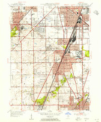 1953 Harvey1955 Print · USGSSouthern Cook County experiences a mid-century suburban surge centered on the rail corridors of Harvey and Homewood. Genealogists and historians can trace family roots through numerous sites like the Oak Forest Infirmary, Markham Yard, and St Johns Sch.
 - 1953 Map of Dyer, 1955 Print
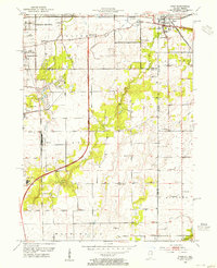 1953 Dyer1955 Print · USGSThe Illinois-Indiana border during the early fifties reveals a landscape of growing suburbs and traditional crossroads. Researchers can trace historic family roots at Eagle Lake Cem or locate lost landmarks like Klemme Sch and Lincoln Fields.
 - 1953 Map of Chicago, 1964 Print
 1953 Chicago1964 Print · USGSThe southern Lake Michigan shoreline was rapidly modernizing in the mid-fifties, balancing heavy industry with its famous academic centers. Researchers can trace the footprints of Notre Dame University or locate vanished sites like the Kingsbury Ordnance Plant and Meigs Field.5 unique versions available
 - 1957 Map of Chicago
 1957 Chicago1957 Print · USGSThe industrial heartland and southern Great Lakes shoreline are captured here during the peak of mid-century growth. Researchers can trace the massive Gary Steel Works, the grounds of the University of Notre Dame, and the early paths of the Tri-State Tollway.
End of results
Showing maps 1-6 of 6
Top cities near Bloom Township
- Chicago historical maps
- Hammond historical maps
- Gary historical maps
- Oak Lawn historical maps
- Orland Park historical maps
- Tinley Park historical maps
See more
Top neighborhoods of Bloom Township
- Chicago Heights historical maps
- Sauk Village historical maps
- Lynwood historical maps
- Glenwood historical maps
- Olympia Fields historical maps
- South Chicago Heights historical maps
See more
Frequently asked questions
- What are the different types of historical maps available for Bloom Township?
- What is the oldest map of Bloom Township?
- Where can I purchase historical maps of Bloom Township for my home or office?
- Where can I download high-res historical maps of Bloom Township?
- Are there historical topographic maps available for Bloom Township?
- Is there historical aerial imagery available for Bloom Township?
- Where are historical maps of Bloom Township sourced from?