1990s Maps of Bloom Township, Illinois
Explore 9 historic maps of Bloom Township from the 1990s. These maps offer a rare glimpse into what life looked like during the 1990s — showing old roads, neighborhoods, homes, and landmarks that have changed or disappeared over time.
Whether you're researching your family's past, planning a metal detecting trip, or studying how Bloom Township's landscape evolved across the 1990s, these high-resolution maps are a powerful tool for exploring the history of this region.
- Focus on a specific era: All maps on this page are from the 1990s, giving you a focused view of this time period.
- See what’s changed: Compare century-old streets, trails, and buildings to today's modern landscape using overlays and satellite layers.
- Research with precision: Use these maps for genealogy, historical research, land use analysis, or educational projects.
- View, download, or print: Maps are fully viewable online in high resolution, and can be downloaded or printed for your own records.
Start exploring Bloom Township's history through authentic maps from the 1990s. This is your window into the past.
Bloom Township, IL maps
(9)- 1990 Map of Dyer, 1991 Print
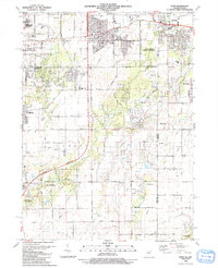 1990 Dyer1991 Print · USGSSuburban development meets the rural prairie at the Illinois and Indiana border in the early nineties. Researchers can trace family sites from Sauk Village to Dyer, including St James Cem and the small settlement of Kreitzburg.
 - 1990 Map of Steger, 1991 Print
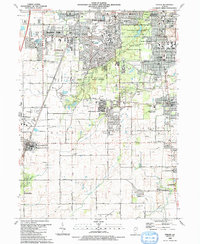 1990 Steger1991 Print · USGSThe south Chicago suburbs of Will and Cook Counties appear in full growth during the late twentieth century. Genealogists and local historians can trace family locations through sites like Evergreen Hill Cem, S Liborius Sch, and the Balmoral Park Racetrack.
 - 1991 Map of Kankakee
 1991 Kankakee1991 Print · USGSThe Illinois-Indiana borderlands come into focus during the early nineties, centered on the growing Kankakee valley and its sprawling drainage systems. Trace the rail-and-river economy through landmarks like the Wilton Railroad Grade, the Manteno State Hospital, and the historic Old Pioneer Cem.
 - 1991 Map of Calumet City, 1992 Print
 1991 Calumet City1992 Print · USGSThe Illinois and Indiana borderlands are captured here in the early nineties, showing the dense intersection of industry and nature. Researchers can trace family roots through local landmarks like Holy Cross Cemetery, Oakland Cem, and Thornridge High Sch.2 unique versions available
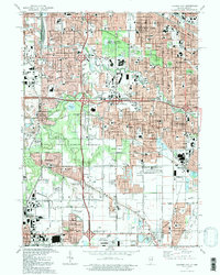
 - 1993 Map of Harvey
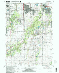
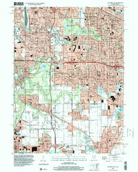
 1993 Harvey1993 Print · USGSSouth Cook County in the early nineties shows a landscape of maturing suburban centers and heavy rail infrastructure. Trace local family history and community growth through sites like Homewood Mem Gdns (Cem), Bloom High Sch, and the Illinois Central Railroad.
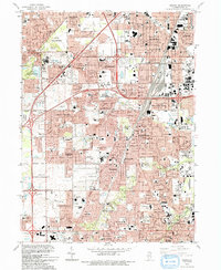
 - 1998 Map of Dyer, 1999 Print
 1998 Dyer1999 Print · USGSThe Illinois and Indiana borderlands at the end of the century reveal a landscape where industrial rail hubs meet expanding suburban life. Genealogists and historians can trace the foundations of Sauk Village and Dyer or locate markers like Eagle Lake Cem and St James Cem.
 - 1998 Map of Calumet City, 2000 Print
 1998 Calumet City2000 Print · USGSCalumet City and Lansing are shown in high detail during the late nineties, documenting the dense suburban and industrial growth along the Indiana border. Researchers can trace local institutions and cemeteries like Assumption Cemetery, St Margaret Hospital, and the Lansing Municipal Airport.
 - 1998 Map of Harvey, 2002 Print
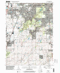
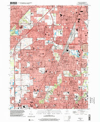 1998 Harvey2002 Print · USGSCook County suburbs south of Chicago show their full residential and industrial maturity in the late nineties. Genealogists can locate family landmarks like St Gabriel Cemetery, the County Cemetery, and schools such as Thornton High Sch.
 - 1998 Map of Steger, 2002 Print
 1998 Steger2002 Print · USGSSuburban expansion meets preserved woodlands south of Chicago in the late nineties. Trace family ties at St Pauls Cem and Adams Cem or locate local landmarks like Governors State University and Sanger Airport.
End of results
Showing maps 1-9 of 9
Top cities near Bloom Township
- Chicago historical maps
- Hammond historical maps
- Gary historical maps
- Oak Lawn historical maps
- Orland Park historical maps
- Tinley Park historical maps
See more
Top neighborhoods of Bloom Township
- Chicago Heights historical maps
- Sauk Village historical maps
- Lynwood historical maps
- Glenwood historical maps
- Olympia Fields historical maps
- South Chicago Heights historical maps
See more
Frequently asked questions
- What are the different types of historical maps available for Bloom Township?
- What is the oldest map of Bloom Township?
- Where can I purchase historical maps of Bloom Township for my home or office?
- Where can I download high-res historical maps of Bloom Township?
- Are there historical topographic maps available for Bloom Township?
- Is there historical aerial imagery available for Bloom Township?
- Where are historical maps of Bloom Township sourced from?