1990s Maps of Rogers Park Township, Chicago
Explore 4 historic maps of Rogers Park Township from the 1990s. These maps offer a rare glimpse into what life looked like during the 1990s — showing old roads, neighborhoods, homes, and landmarks that have changed or disappeared over time.
Whether you're researching your family's past, planning a metal detecting trip, or studying how Rogers Park Township's landscape evolved across the 1990s, these high-resolution maps are a powerful tool for exploring the history of this region.
- Focus on a specific era: All maps on this page are from the 1990s, giving you a focused view of this time period.
- See what’s changed: Compare century-old streets, trails, and buildings to today's modern landscape using overlays and satellite layers.
- Research with precision: Use these maps for genealogy, historical research, land use analysis, or educational projects.
- View, download, or print: Maps are fully viewable online in high resolution, and can be downloaded or printed for your own records.
Start exploring Rogers Park Township's history through authentic maps from the 1990s. This is your window into the past.
Rogers Park Township, Chicago maps
(4)- 1993 Map of Evanston
 1993 Evanston1993 Print · USGSThe North Shore suburbs of Evanston and Wilmette are shown here during the early nineties, revealing a dense grid of lakefront neighborhoods and prestigious institutions. Genealogists and local historians can trace the grounds of Calvary Cemetery, Loyola University, and the unique Bahai Temple.
 - 1993 Map of Chicago Loop
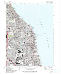
 1993 Chicago Loop1993 Print · USGSChicago in the early nineties displays a massive urban landscape anchored by its iconic shoreline and central business district. Genealogists and historians can trace family plots in Rosehill Cemetery or locate historic landmarks like the Sears Tower and the Merchandise Mart.2 unique versions available
 - 1995 Map of Evanston, 1999 Print
 1995 Evanston1999 Print · USGSThe North Shore's residential and institutional landscape is captured here in the late twentieth century. Genealogists and historians can trace the campuses of Northwestern University, the Bahai Temple, and the sprawling Calvary Cemetery.
 - 1997 Map of Chicago Loop, 1999 Print
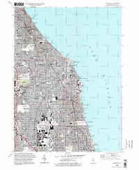
 1997 Chicago Loop1999 Print · USGSChicago at the end of the twentieth century remains a city of grand parks and intricate waterways. Genealogists and urban historians can trace the vast grounds of Rosehill Cemetery or locate neighborhood landmarks like St Mary of the Angels Ch and Navy Pier.
End of results
Showing maps 1-4 of 4
Top cities near Rogers Park Township
- Chicago historical maps
- Cicero historical maps
- Evanston historical maps
- Skokie historical maps
- Des Plaines historical maps
- Berwyn historical maps
See more
Top neighborhoods of Rogers Park Township
- Rogers Park historical maps
- Little India historical maps
- Jarvis Square historical maps
- Glenwood Arts District historical maps
Frequently asked questions
- What are the different types of historical maps available for Rogers Park Township?
- What is the oldest map of Rogers Park Township?
- Where can I purchase historical maps of Rogers Park Township for my home or office?
- Where can I download high-res historical maps of Rogers Park Township?
- Are there historical topographic maps available for Rogers Park Township?
- Is there historical aerial imagery available for Rogers Park Township?
- Where are historical maps of Rogers Park Township sourced from?