1920s Maps of Matteson, Rich Township
Explore 2 historic maps of Matteson from the 1920s. These maps offer a rare glimpse into what life looked like during the 1920s — showing old roads, neighborhoods, homes, and landmarks that have changed or disappeared over time.
Whether you're researching your family's past, planning a metal detecting trip, or studying how Matteson's landscape evolved across the 1920s, these high-resolution maps are a powerful tool for exploring the history of this region.
- Focus on a specific era: All maps on this page are from the 1920s, giving you a focused view of this time period.
- See what’s changed: Compare century-old streets, trails, and buildings to today's modern landscape using overlays and satellite layers.
- Research with precision: Use these maps for genealogy, historical research, land use analysis, or educational projects.
- View, download, or print: Maps are fully viewable online in high resolution, and can be downloaded or printed for your own records.
Start exploring Matteson's history through authentic maps from the 1920s. This is your window into the past.
Matteson, Rich Township maps
(2)- 1929 Map of Tinley Park
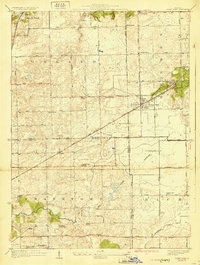 1929 Tinley Park1929 Print · USGSThe Cook and Will County borderlands appear here in the late twenties, showing the early suburban footprints of Tinley Park and Orland Park. Researchers can trace rural school locations like Sedan Prairie School or family sites near the Frankfort Cemetery.3 unique versions available
 - 1929 Map of Harvey
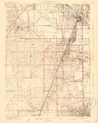 1929 Harvey1929 Print · USGSSouthern Cook County emerges as a major rail and residential hub in the late twenties. Genealogists and historians can trace the development of Markham Yards, find the Glenwood Manual Training School, and locate St Johns Sch and local cemeteries.4 unique versions available
End of results
Showing maps 1-2 of 2
Top cities near Matteson
- Chicago historical maps
- Hammond historical maps
- Oak Lawn historical maps
- Orland Park historical maps
- Tinley Park historical maps
- Calumet City historical maps
See more
Top neighborhoods of Matteson
- Michael John Manor historical maps
- Ridgeland Manor historical maps
- Maple Brook historical maps
- The Point at Gleneagle Trail historical maps
- Creekside historical maps
- Providence Manor historical maps
See more
Frequently asked questions
- What are the different types of historical maps available for Matteson?
- What is the oldest map of Matteson?
- Where can I purchase historical maps of Matteson for my home or office?
- Where can I download high-res historical maps of Matteson?
- Are there historical topographic maps available for Matteson?
- Is there historical aerial imagery available for Matteson?
- Where are historical maps of Matteson sourced from?