1990s Maps of Matteson, Rich Township
Explore 7 historic maps of Matteson from the 1990s. These maps offer a rare glimpse into what life looked like during the 1990s — showing old roads, neighborhoods, homes, and landmarks that have changed or disappeared over time.
Whether you're researching your family's past, planning a metal detecting trip, or studying how Matteson's landscape evolved across the 1990s, these high-resolution maps are a powerful tool for exploring the history of this region.
- Focus on a specific era: All maps on this page are from the 1990s, giving you a focused view of this time period.
- See what’s changed: Compare century-old streets, trails, and buildings to today's modern landscape using overlays and satellite layers.
- Research with precision: Use these maps for genealogy, historical research, land use analysis, or educational projects.
- View, download, or print: Maps are fully viewable online in high resolution, and can be downloaded or printed for your own records.
Start exploring Matteson's history through authentic maps from the 1990s. This is your window into the past.
Matteson, Rich Township maps
(7)- 1990 Map of Steger, 1991 Print
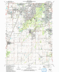 1990 Steger1991 Print · USGSThe south Chicago suburbs of Will and Cook Counties appear in full growth during the late twentieth century. Genealogists and local historians can trace family locations through sites like Evergreen Hill Cem, S Liborius Sch, and the Balmoral Park Racetrack.
 - 1990 Map of Frankfort, 1991 Print
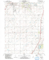 1990 Frankfort1991 Print · USGSWill County's transition from prairie farmland to suburban community is captured here as the nineties approached. Genealogists and local historians can trace family plots at St Peters Cem and Union Cem, or follow the path of the Old Indian Boundary.
 - 1991 Map of Kankakee
 1991 Kankakee1991 Print · USGSThe Illinois-Indiana borderlands come into focus during the early nineties, centered on the growing Kankakee valley and its sprawling drainage systems. Trace the rail-and-river economy through landmarks like the Wilton Railroad Grade, the Manteno State Hospital, and the historic Old Pioneer Cem.
 - 1993 Map of Harvey
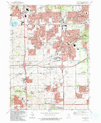
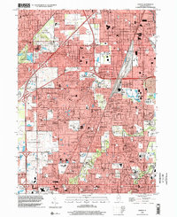
 1993 Harvey1993 Print · USGSSouth Cook County in the early nineties shows a landscape of maturing suburban centers and heavy rail infrastructure. Trace local family history and community growth through sites like Homewood Mem Gdns (Cem), Bloom High Sch, and the Illinois Central Railroad.
 - 1993 Map of Tinley Park
 1993 Tinley Park1993 Print · USGSSuburban development sweeps across the Cook and Will County line in the early nineties, revealing a landscape of rapid growth and community expansion. Genealogists and local historians can trace family-named sites like Hickory Cem and Frankfort Cem or find vanished landmarks like the Drive-in Theater.
 - 1998 Map of Harvey, 2002 Print
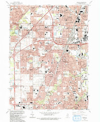
 1998 Harvey2002 Print · USGSCook County suburbs south of Chicago show their full residential and industrial maturity in the late nineties. Genealogists can locate family landmarks like St Gabriel Cemetery, the County Cemetery, and schools such as Thornton High Sch.
 - 1998 Map of Steger, 2002 Print
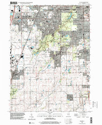 1998 Steger2002 Print · USGSSuburban expansion meets preserved woodlands south of Chicago in the late nineties. Trace family ties at St Pauls Cem and Adams Cem or locate local landmarks like Governors State University and Sanger Airport.
End of results
Showing maps 1-7 of 7
Top cities near Matteson
- Chicago historical maps
- Hammond historical maps
- Oak Lawn historical maps
- Orland Park historical maps
- Tinley Park historical maps
- Calumet City historical maps
See more
Top neighborhoods of Matteson
- Michael John Manor historical maps
- Ridgeland Manor historical maps
- Maple Brook historical maps
- The Point at Gleneagle Trail historical maps
- Creekside historical maps
- Providence Manor historical maps
See more
Frequently asked questions
- What are the different types of historical maps available for Matteson?
- What is the oldest map of Matteson?
- Where can I purchase historical maps of Matteson for my home or office?
- Where can I download high-res historical maps of Matteson?
- Are there historical topographic maps available for Matteson?
- Is there historical aerial imagery available for Matteson?
- Where are historical maps of Matteson sourced from?