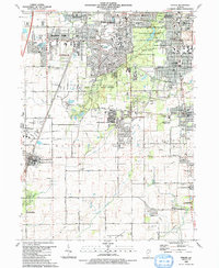
1990 Map of Steger
USGS Topo · Published 1991About this map
Suburban expansion and dedicated conservation corridors define this segment of the south Chicago region as recorded in the late 1980s. The landscape transitions from the dense residential grids of Park Forest and Chicago Heights into the more open spaces of University Park and Monee. A significant portion of the area is preserved in a series of large ecological tracts, including the Thorn Creek Forest Preserve and Raccoon Grove Forest Preserve, which protect local drainages like Deer Creek. Transport infrastructure is prominent, featuring the Illinois Central Railroad and the Chicago and Eastern Illinois Railroad alongside the historic Sauk Trail. Local community life is anchored by numerous institutions, from the Balmoral Park Racetrack in the south to long-established centers like Steger and Crete, where St Pauls Cem and several parochial schools suggest a deeply rooted settlement history.
Find a feature on this map
78 named features on this map. Tap any name to fly to it.
Don’t see what you’re looking for? This feature index may not catch every label — zoom into the map to look around manually.
Map Details
Editions of this 1990 Steger Map
This is the sole edition of this map. No revisions or reprints were ever made.
Other maps of this area

1890 · Des Plaines
USGS Topo · 1:62,500

1892 · Calumet
USGS Topo · 1:62,500

1893 · Calumet
USGS Topo · 1:62,500

1894 · Des Plaines
USGS Topo · 1:62,500

1900 · Des Plaines
USGS Topo · 1:62,500

1900 · Calumet
USGS Topo · 1:62,500

1901 · Calumet
USGS Topo · 1:62,500

1901 · Des Plaines
USGS Topo · 1:62,500

1929 · Tinley Park
USGS Topo · 1:24,000

1929 · Calumet City
USGS Topo · 1:24,000