1990s Maps of Dieterich, Illinois
Explore 2 historic maps of Dieterich from the 1990s. These maps offer a rare glimpse into what life looked like during the 1990s — showing old roads, neighborhoods, homes, and landmarks that have changed or disappeared over time.
Whether you're researching your family's past, planning a metal detecting trip, or studying how Dieterich's landscape evolved across the 1990s, these high-resolution maps are a powerful tool for exploring the history of this region.
- Focus on a specific era: All maps on this page are from the 1990s, giving you a focused view of this time period.
- See what’s changed: Compare century-old streets, trails, and buildings to today's modern landscape using overlays and satellite layers.
- Research with precision: Use these maps for genealogy, historical research, land use analysis, or educational projects.
- View, download, or print: Maps are fully viewable online in high resolution, and can be downloaded or printed for your own records.
Start exploring Dieterich's history through authentic maps from the 1990s. This is your window into the past.
Dieterich, IL maps
(2)- 1998 Map of Wheeler, 2003 Print
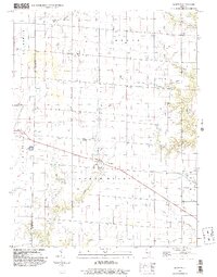 1998 Wheeler2003 Print · USGSJasper and Effingham counties are captured here at the end of the millennium, showing a landscape of productive prairie farms and quiet rural townships. Genealogists and researchers can trace the roads and waterways connecting Wheeler, Island Grove, and Gila.
 - 1998 Map of Dieterich, 2003 Print
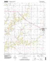 1998 Dieterich2003 Print · USGSDieterich and the surrounding Effingham County townships are shown here at the turn of the millennium. Genealogists and researchers can trace local landmarks like Elliottstown, the Cem south of town, and watercourses such as Bishop Creek.
End of results
Showing maps 1-2 of 2
Top cities near Dieterich
- Effingham historical maps
- Newton historical maps
- Teutopolis historical maps
- Greenup historical maps
- Toledo historical maps
- Watson historical maps
See more
Frequently asked questions
- What are the different types of historical maps available for Dieterich?
- What is the oldest map of Dieterich?
- Where can I purchase historical maps of Dieterich for my home or office?
- Where can I download high-res historical maps of Dieterich?
- Are there historical topographic maps available for Dieterich?
- Is there historical aerial imagery available for Dieterich?
- Where are historical maps of Dieterich sourced from?