1900s (20th Century) Maps of Vandalia, Illinois
Explore 7 historic maps of Vandalia from the 1900s (20th Century). These maps offer a rare glimpse into what life looked like during the 1900s — showing old roads, neighborhoods, homes, and landmarks that have changed or disappeared over time.
Whether you're researching your family's past, planning a metal detecting trip, or studying how Vandalia's landscape evolved across the 1900s, these high-resolution maps are a powerful tool for exploring the history of this region.
- Focus on a specific era: All maps on this page are from the 1900s, giving you a focused view of this time period.
- See what’s changed: Compare century-old streets, trails, and buildings to today's modern landscape using overlays and satellite layers.
- Research with precision: Use these maps for genealogy, historical research, land use analysis, or educational projects.
- View, download, or print: Maps are fully viewable online in high resolution, and can be downloaded or printed for your own records.
Start exploring Vandalia's history through authentic maps from the 1900s. This is your window into the past.
Vandalia, IL maps
(7)- 1945 Map of Vandalia, 1969 Print
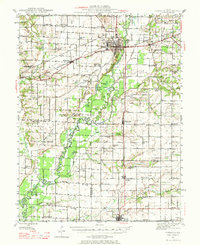 1945 Vandalia1969 Print · USGSMid-century Fayette County life centered on the Kaskaskia River and the rail-connected hub of Vandalia. Genealogists can trace family names through dozens of rural landmarks, from the Mc Inturff Cem to school sites like Clover College Sch and Elm Grove Sch.
 - 1947 Map of Vandalia
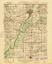 1947 Vandalia1947 Print · USGSThe Kaskaskia River valley in the post-war era shows a landscape of busy rail junctions and rural school districts. Genealogists can trace family names through dozens of landmarks like Evans Cem, Clover College Sch, and the community of Hagarstown.
 - 1958 Map of Belleville, 1973 Print
 1958 Belleville1973 Print · USGSSouthern Illinois during the mid-twentieth century reveals a landscape of industrial growth and massive new reservoirs. Genealogists and historians can trace the paths of the Illinois Central RR through towns like Centralia or locate landmarks such as Emerald Mound and the Looking Glass Prairie.3 unique versions available
 - 1962 Map of Belleville
 1962 Belleville1962 Print · USGSSouthern Illinois in the late fifties reveals a landscape of industrial growth and ancient landmarks before the full expansion of the interstate system. Genealogists can trace family names and rural post offices near Centralia, Salem, and the historic Monks Mound.
 - 1974 Map of Vandalia, 1977 Print
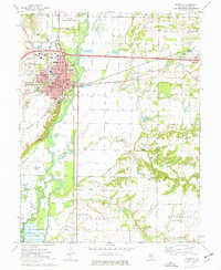 1974 Vandalia1977 Print · USGSVandalia and the Kaskaskia River valley are captured in the mid-seventies, showing the intersection of state history and river navigation. Genealogists and local historians can trace legacy sites like Old State Cem, Luster Chapel, and the Vandalia Correctional Center.
 - 1974 Map of Hagarstown, 1977 Print
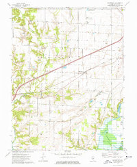 1974 Hagarstown1977 Print · USGSFayette County was characterized by a transition from traditional rail-side settlements to modern reservoir landscapes in the 1970s. You can trace family history at Evans Cem and Hurricane Ch or explore the early infrastructure of Carlyle Lake.
 - 1985 Map of Carlyle Lake
 1985 Carlyle Lake1985 Print · USGSSouthwestern Illinois in the mid-eighties shows a landscape of growing commuter suburbs and massive water management projects. Genealogists and historians can locate family plots at Lakeview Memorial Gardens Cem or trace the early footprint of Southern Illinois Univ (Edwardsville).2 unique versions available
End of results
Showing maps 1-7 of 7
Top cities near Vandalia
- Avena historical maps
- Ramsey historical maps
- Pleasant Mound historical maps
- Brownstown historical maps
- Patoka historical maps
- Sefton historical maps
See more
Frequently asked questions
- What are the different types of historical maps available for Vandalia?
- What is the oldest map of Vandalia?
- Where can I purchase historical maps of Vandalia for my home or office?
- Where can I download high-res historical maps of Vandalia?
- Are there historical topographic maps available for Vandalia?
- Is there historical aerial imagery available for Vandalia?
- Where are historical maps of Vandalia sourced from?