1970s Maps of Vandalia, Illinois
Explore 2 historic maps of Vandalia from the 1970s. These maps offer a rare glimpse into what life looked like during the 1970s — showing old roads, neighborhoods, homes, and landmarks that have changed or disappeared over time.
Whether you're researching your family's past, planning a metal detecting trip, or studying how Vandalia's landscape evolved across the 1970s, these high-resolution maps are a powerful tool for exploring the history of this region.
- Focus on a specific era: All maps on this page are from the 1970s, giving you a focused view of this time period.
- See what’s changed: Compare century-old streets, trails, and buildings to today's modern landscape using overlays and satellite layers.
- Research with precision: Use these maps for genealogy, historical research, land use analysis, or educational projects.
- View, download, or print: Maps are fully viewable online in high resolution, and can be downloaded or printed for your own records.
Start exploring Vandalia's history through authentic maps from the 1970s. This is your window into the past.
Vandalia, IL maps
(2)- 1974 Map of Vandalia, 1977 Print
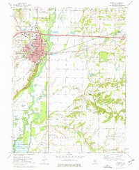 1974 Vandalia1977 Print · USGSVandalia and the Kaskaskia River valley are captured in the mid-seventies, showing the intersection of state history and river navigation. Genealogists and local historians can trace legacy sites like Old State Cem, Luster Chapel, and the Vandalia Correctional Center.
 - 1974 Map of Hagarstown, 1977 Print
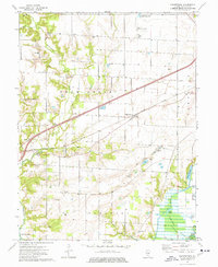 1974 Hagarstown1977 Print · USGSFayette County was characterized by a transition from traditional rail-side settlements to modern reservoir landscapes in the 1970s. You can trace family history at Evans Cem and Hurricane Ch or explore the early infrastructure of Carlyle Lake.
End of results
Showing maps 1-2 of 2
Top cities near Vandalia
- Avena historical maps
- Ramsey historical maps
- Pleasant Mound historical maps
- Brownstown historical maps
- Patoka historical maps
- Sefton historical maps
See more
Frequently asked questions
- What are the different types of historical maps available for Vandalia?
- What is the oldest map of Vandalia?
- Where can I purchase historical maps of Vandalia for my home or office?
- Where can I download high-res historical maps of Vandalia?
- Are there historical topographic maps available for Vandalia?
- Is there historical aerial imagery available for Vandalia?
- Where are historical maps of Vandalia sourced from?