1930s Maps of Franklin County, Illinois
Explore 3 historic maps of Franklin County from the 1930s. These maps offer a rare glimpse into what life looked like during the 1930s — showing old roads, neighborhoods, homes, and landmarks that have changed or disappeared over time.
Whether you're researching your family's past, planning a metal detecting trip, or studying how Franklin County's landscape evolved across the 1930s, these high-resolution maps are a powerful tool for exploring the history of this region.
- Focus on a specific era: All maps on this page are from the 1930s, giving you a focused view of this time period.
- See what’s changed: Compare century-old streets, trails, and buildings to today's modern landscape using overlays and satellite layers.
- Research with precision: Use these maps for genealogy, historical research, land use analysis, or educational projects.
- View, download, or print: Maps are fully viewable online in high resolution, and can be downloaded or printed for your own records.
Start exploring Franklin County's history through authentic maps from the 1930s. This is your window into the past.
Franklin County, IL maps
(3)- 1936 Map of Herrin
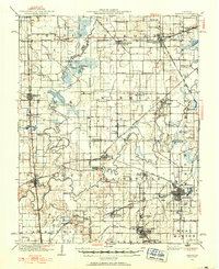 1936 Herrin1936 Print · USGSSouthern Illinois was defined by its coal-and-rail economy in the 1930s as industrial lines reached deep into the countryside. Trace the family landmarks of this era at Old Duquoin, Buckner Pond, and the Union Hill Church.2 unique versions available
 - 1938 Map of Galatia, 1959 Print
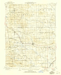 1938 Galatia1959 Print · USGSThe Southern Illinois interior near the Saline River comes to life in this survey from the late thirties. Genealogists and historians can trace family roots through numerous local landmarks like Thistle Ridge School, Tate Chapel, and Akin.
 - 1939 Map of Ina, 1958 Print
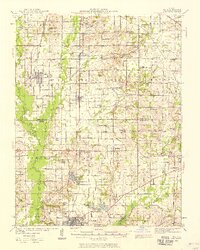 1939 Ina1958 Print · USGSJefferson and Franklin Counties appear here as they were in the late 1930s, showing a landscape of fertile prairies and growing rail towns. Researchers can trace dozens of family-named schools and landmarks like King College, the STATE GAME FARM, and the Antioch Ch cemetery.2 unique versions available
End of results
Showing maps 1-3 of 3
Top cities of Franklin County
- West Frankfort historical maps
- Benton historical maps
- Christopher historical maps
- Sesser historical maps
- Zeigler historical maps
- Royalton historical maps
See more
Frequently asked questions
- What are the different types of historical maps available for Franklin County?
- What is the oldest map of Franklin County?
- Where can I purchase historical maps of Franklin County for my home or office?
- Where can I download high-res historical maps of Franklin County?
- Are there historical topographic maps available for Franklin County?
- Is there historical aerial imagery available for Franklin County?
- Where are historical maps of Franklin County sourced from?