1900-1909 Maps of Franklin County, Illinois
Explore 2 historic maps of Franklin County from 1900-1909. These maps offer a rare glimpse into what life looked like during the 1900s — showing old roads, neighborhoods, homes, and landmarks that have changed or disappeared over time.
Whether you're researching your family's past, planning a metal detecting trip, or studying how Franklin County's landscape evolved across the 1900s, these high-resolution maps are a powerful tool for exploring the history of this region.
- Focus on a specific era: All maps on this page are from the 1900s, giving you a focused view of this time period.
- See what’s changed: Compare century-old streets, trails, and buildings to today's modern landscape using overlays and satellite layers.
- Research with precision: Use these maps for genealogy, historical research, land use analysis, or educational projects.
- View, download, or print: Maps are fully viewable online in high resolution, and can be downloaded or printed for your own records.
Start exploring Franklin County's history through authentic maps from the 1900s. This is your window into the past.
Franklin County, IL maps
(2)- 1908 Map of Galatia
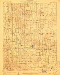 1908 Galatia1908 Print · USGSSouthern Illinois at the dawn of the twentieth century was a landscape of thriving rural communities and rail-side towns. Genealogists can trace family roots through numerous local landmarks like Possum Flat School, Tate Township Hall, and Mount Pleasant Church.2 unique versions available
 - 1909 Map of West Frankfort
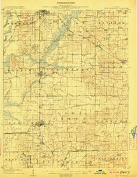 1909 West Frankfort1909 Print · USGSSouthern Illinois at the peak of the coal and rail boom is captured here across Franklin and Williamson counties. Genealogists can locate family landmarks like Coon Ridge School, Mormon Church, and small settlements such as Smothersville or Deering City.2 unique versions available
End of results
Showing maps 1-2 of 2
Top cities of Franklin County
- West Frankfort historical maps
- Benton historical maps
- Christopher historical maps
- Sesser historical maps
- Zeigler historical maps
- Royalton historical maps
See more
Frequently asked questions
- What are the different types of historical maps available for Franklin County?
- What is the oldest map of Franklin County?
- Where can I purchase historical maps of Franklin County for my home or office?
- Where can I download high-res historical maps of Franklin County?
- Are there historical topographic maps available for Franklin County?
- Is there historical aerial imagery available for Franklin County?
- Where are historical maps of Franklin County sourced from?