1970s Maps of Grundy County, Illinois
Explore 4 historic maps of Grundy County from the 1970s. These maps offer a rare glimpse into what life looked like during the 1970s — showing old roads, neighborhoods, homes, and landmarks that have changed or disappeared over time.
Whether you're researching your family's past, planning a metal detecting trip, or studying how Grundy County's landscape evolved across the 1970s, these high-resolution maps are a powerful tool for exploring the history of this region.
- Focus on a specific era: All maps on this page are from the 1970s, giving you a focused view of this time period.
- See what’s changed: Compare century-old streets, trails, and buildings to today's modern landscape using overlays and satellite layers.
- Research with precision: Use these maps for genealogy, historical research, land use analysis, or educational projects.
- View, download, or print: Maps are fully viewable online in high resolution, and can be downloaded or printed for your own records.
Start exploring Grundy County's history through authentic maps from the 1970s. This is your window into the past.
Grundy County, IL maps
(4)- 1970 Map of Seneca, 1972 Print
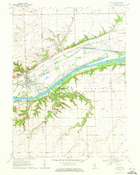 1970 Seneca1972 Print · USGSThe Seneca riverfront and its industrial corridor are captured here during the 1970s. Researchers can trace the path of the Illinois and Michigan Canal (Abandoned) and locate the U.S. Govt Reservation and the village of Langham.2 unique versions available
 - 1970 Map of Stavanger, 1972 Print
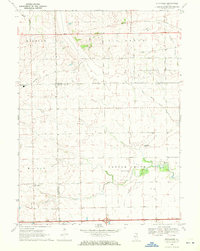 1970 Stavanger1972 Print · USGSThe rural prairie lands of Grundy and LaSalle counties are shown in detail as they appeared in the early seventies. Genealogists can locate family names at Holderman and Hoge Cem or trace the local community near Stavanger and the Nettle Creek Sch.
 - 1973 Map of Essex, 1975 Print
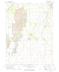 1973 Essex1975 Print · USGSIn the early 1970s, the landscape around the Grundy and Kankakee county line was shaped by heavy industry and rail. Genealogists and historians can trace the local cemetery sites and industrial hubs like Strip Mine, Clarke City, and Custer Park.3 unique versions available
 - 1973 Map of Buckingham, 1975 Print
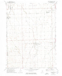 1973 Buckingham1975 Print · USGSThe Illinois prairie near the Kankakee county line is captured in the early 1970s, showcasing a rural landscape structured by rail and water. Researchers can trace the paths of the Norfolk and Western and Illinois Central Gulf through Buckingham and Union Hill.
End of results
Showing maps 1-4 of 4
Top cities of Grundy County
- Morris historical maps
- Wauponsee historical maps
- Gardner historical maps
- Mazon historical maps
- South Wilmington historical maps
- Carbon Hill historical maps
See more
Frequently asked questions
- What are the different types of historical maps available for Grundy County?
- What is the oldest map of Grundy County?
- Where can I purchase historical maps of Grundy County for my home or office?
- Where can I download high-res historical maps of Grundy County?
- Are there historical topographic maps available for Grundy County?
- Is there historical aerial imagery available for Grundy County?
- Where are historical maps of Grundy County sourced from?