1980s Maps of Grundy County, Illinois
Explore 7 historic maps of Grundy County from the 1980s. These maps offer a rare glimpse into what life looked like during the 1980s — showing old roads, neighborhoods, homes, and landmarks that have changed or disappeared over time.
Whether you're researching your family's past, planning a metal detecting trip, or studying how Grundy County's landscape evolved across the 1980s, these high-resolution maps are a powerful tool for exploring the history of this region.
- Focus on a specific era: All maps on this page are from the 1980s, giving you a focused view of this time period.
- See what’s changed: Compare century-old streets, trails, and buildings to today's modern landscape using overlays and satellite layers.
- Research with precision: Use these maps for genealogy, historical research, land use analysis, or educational projects.
- View, download, or print: Maps are fully viewable online in high resolution, and can be downloaded or printed for your own records.
Start exploring Grundy County's history through authentic maps from the 1980s. This is your window into the past.
Grundy County, IL maps
(7)- 1983 Map of Dwight
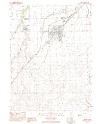 1983 Dwight1983 Print · USGSThe village of Dwight is shown in the early 1980s as a significant rail and agricultural crossroads in Livingston County. Genealogists and local historians can trace the locations of Oak Lawn Cem, the Dwight Correctional Center, and the PO in the heart of town.
 - 1983 Map of Kinsman
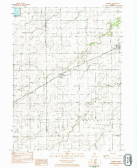 1983 Kinsman1983 Print · USGSThe Illinois prairie of the early eighties is mapped here at the border of La Salle and Grundy Counties. Genealogists and local historians can trace the rail corridor of the Atchison Topeka and Santa Fe and locate family sites near Highland Cem or the village of Kinsman.
 - 1983 Map of Campus
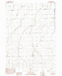 1983 Campus1983 Print · USGSLivingston County farm country is captured here in the early eighties as a network of rail lines and small prairie villages. Genealogists can locate family sites at Sacred Heart Cem or trace the development of Campus, Reddick, and the former mining center of Cardiff.
 - 1983 Map of Gardner
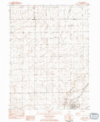
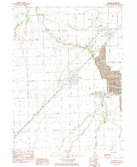 1983 Gardner1983 Print · USGSThe Illinois coal fields of Grundy County are seen here in the early eighties, where industrial mining and prairie farming meet. Researchers can trace the sprawling Mine Dumps near South Wilmington or find family landmarks like Cotton Cem.
 - 1983 Map of Mazon
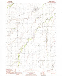 1983 Mazon1983 Print · USGSGrundy County farmland and the river valleys are meticulously detailed here in the early eighties. Genealogists and local historians can locate Goodfarm Cem, the village of Verona, and the historic Atchison Topeka and Santa Fe rail line.2 unique versions available
 - 1983 Map of Odell
 1983 Odell1983 Print · USGSAgricultural life in central Illinois reached a turning point in the early eighties as these rail corridors and small towns evolved. Genealogists and local researchers can pinpoint the locations of Nevada Cem, the St Paul Cem, and the rural post office sites of Budd and Sunbury.
 - 1985 Map of Ottawa
 1985 Ottawa1985 Print · USGSThe Illinois River valley in the mid-1980s shows a landscape balancing river commerce with sprawling energy and mining operations. Researchers can trace the layout of mining towns like Coal City or find family landmarks such as Oakwood Memorial Cem and Smiths Mound.
End of results
Showing maps 1-7 of 7
Top cities of Grundy County
- Morris historical maps
- Wauponsee historical maps
- Gardner historical maps
- Mazon historical maps
- South Wilmington historical maps
- Carbon Hill historical maps
See more
Frequently asked questions
- What are the different types of historical maps available for Grundy County?
- What is the oldest map of Grundy County?
- Where can I purchase historical maps of Grundy County for my home or office?
- Where can I download high-res historical maps of Grundy County?
- Are there historical topographic maps available for Grundy County?
- Is there historical aerial imagery available for Grundy County?
- Where are historical maps of Grundy County sourced from?