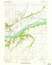
1970 Map of Seneca
USGS Topo · Published 1972About this map
The Illinois River corridor near Seneca is defined by a dense intersection of historical industrial and transport infrastructure during the 1970s. The landscape reflects the transition from early commerce to modern industry, with the Illinois and Michigan Canal (Abandoned) running parallel to the active Chicago Rock Island and Pacific railroad lines. Significant river features like Grist Island, Barry Island, and McNellis Bayou punctuate the waterway, while the local economy is anchored by a large Chemical Plant and several Gravel Pits.
Find a feature on this map
30 named features on this map. Tap any name to fly to it.
Don’t see what you’re looking for? This feature index may not catch every label — zoom into the map to look around manually.
Map Details
Editions of this 1970 Seneca Map
2 editions found
Other maps of this area

1892 · Morris
USGS Topo · 1:62,500

1892 · Marseilles
USGS Topo · 1:62,500

1916 · Marseilles
USGS Topo · 1:62,500

1918 · Morris
USGS Topo · 1:62,500

1940 · Marseilles
USGS Topo · 1:62,500

1948 · Dwight
USGS Topo · 1:62,500

1950 · Dwight
USGS Topo · 1:62,500

1953 · Morris
USGS Topo · 1:24,000

1953 · Lisbon
USGS Topo · 1:24,000
1954 · Morris
USGS Topo · 1:62,500